• Sunset Park Trail view
  • Sunset Park Trail Bird Watching Tower

SUNSET PARK TRAIL FEATURES
·       Evidence of early logging
·       Culturally Modified Trees
·       Bird-watching

ABOUT

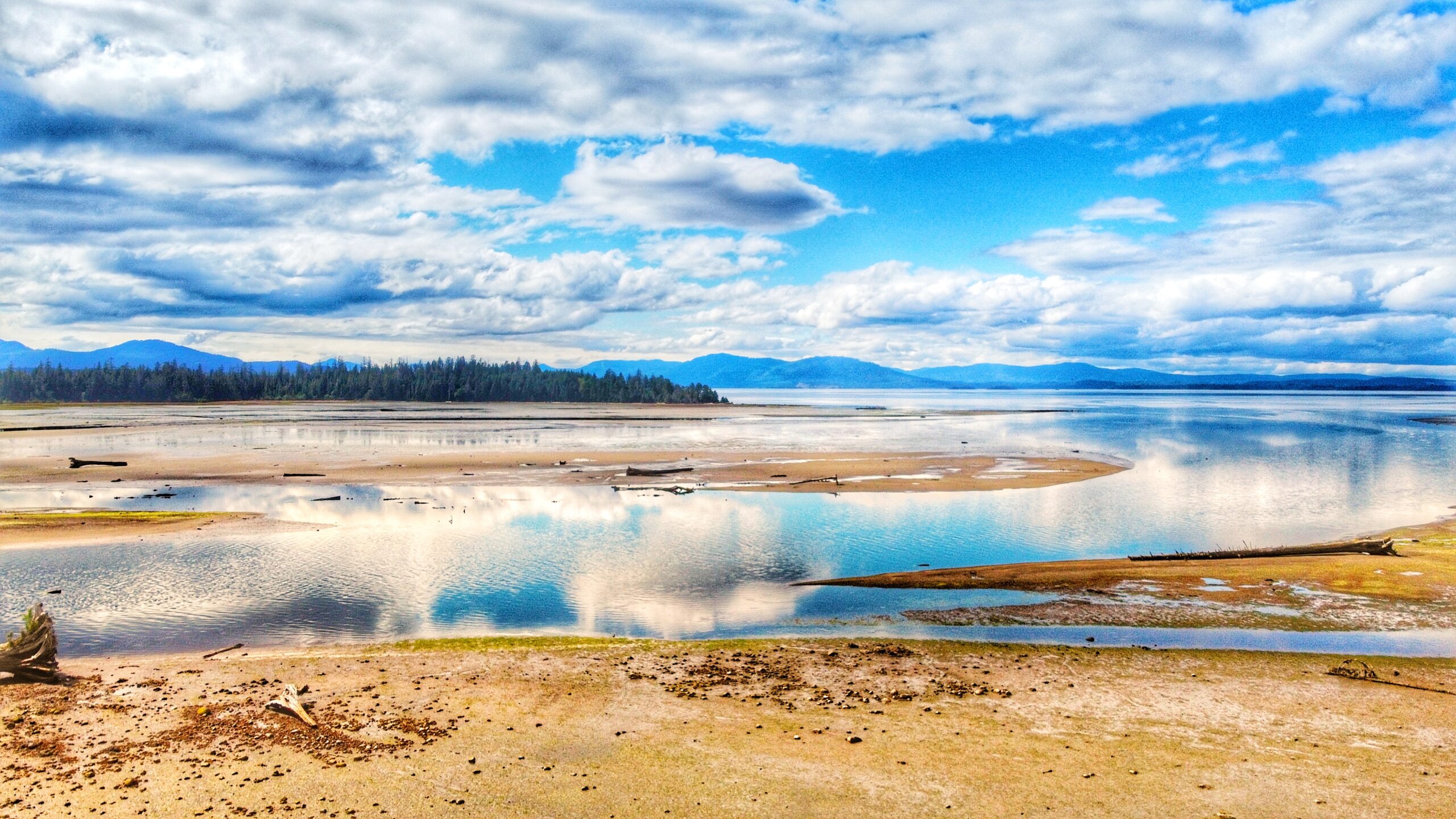
The Sunset Park Trail, located along Bayview Drive, is an easy 2.7km out-and-back trail in the Village of Port Clements. The terrain is flat and basically follows the Yakoun Estuary the entire way. The track is so flat, in fact, that Port Clements even suggests it is wheelchair friendly.

The scenery along the route is quite beautiful at low tide but is, I think, a little one-note if you’re walking the trail at high tide. As you stroll about the path, there are a few strategically placed benches facing the estuary so that one can fully take in and appreciate, the vivid scenes unfolding before them. In addition, there are a couple of interpretive signs along the trail, which link to Port’s early logging history.

For us, the highlight here is the clear evidence of springboard logging. It’s an interesting callback to the golden age of logging on Haida Gwaii.

At the trail’s terminus point, you will come upon a beautiful two-storey birdwatching tower. Climb the stairs (or walk the wheelchair ramp) to receive unobstructed views of Yakoun Bay and watch the Herons and Eagles frolic and play. On a clear day, it’s quite easy for one to get “lost” up here.

Once you’ve finished your Sunset Park Trail adventure, walk back the way you came or take one of the many exits out onto the main road for a more urban hike.

As far as trails on Haida Gwaii go, this one is definitely the easiest in terms of difficulty (well, this one and the Government Dock “trails”). In that respect, seasoned hikers – or even newbies – may find it a little underwhelming; however, there is no denying that it’s suitable for the whole family. 

The birding tower is a lot of fun and we enjoyed the references to logging’s glory years. We should note, by way of conclusion, that the Sunset Park Trail had an extension developed in 2016, which adds just over the original trail described above. The extension begins at the Sunset Park Trail parking lot, just off Bayview Drive. 

Once you park your vehicle, follow the well-manicured path to the right (besides a newly installed pit toilet). After about a minute or two, you must cross the road to continue the trail. The extension then follows alongside Bayview Drive for approximately 300 meters before going up a slight incline and snaking behind Yakoun, Tingley and Park Streets. 

At this point, you almost feel as if you’re trespassing because you come into such close proximity to private homes. The trail eventually passes by Port Clements’ Community Park (home to annual Canada Day celebrations) and follows Falcon Street before ducking into a wooded area and emerging at Bayview Drive, across from the Port Clements Museum.

Like the “original” Sunset Park Trail, the extension is also wheelchair friendly; however, in our view, the extension lacks the appeal of the original trail. It is far more urban and was developed more for locals as a quick way to navigate the community. As such, we’d recommend sticking to the “original” route.

DIFFICULTY: Easy
TOTAL DISTANCE: 7.6 kilometers return (incl. extension)
TIME: 2 hours
TYPE: Out-and-Back
ELEVATION GAIN: None

5-Mile Marker Waterfalls Trail
Quick & easy to access
Relaxing spot

ABOUT

While there are a number of nice waterfalls on Haida Gwaii, most are either extremely remote and/or
require a bit of effort to get to – some are some exceptions like the 5-Mile Marker Waterfall Trail. Then there are a select few that are relatively easy to access – even with a standard vehicle.


To access this small waterfall, simply drive approximately five kilometres along the QC Mainline. As you
approach the “5 Mile Marker,” you should see the cascade to your RIGHT just off the side of the road.
Once here, you can admire it from the safety of your vehicle or pull off the road as much as possible and
then walk down to the waterfall.

If the road maintenance is decent, any SUV or standard car can be able to drive the stretch without no issues. Since it is a logging road, caution is always good on days logging trucks are actively using the QC Mainline roads.

Someone has marked the small creek with tape – no doubt to signify this lovely attraction! Once we’d meandered down to the base of these minor falls, we couldn’t help but be drawn into it – raw and beautiful nature at its best. We stood and admired the falls for several minutes; the rushing water relaxing against the pitter-patter of falling rain.


We should end this entry by offering a couple of important notes:
1) This waterfall, like most small waterfalls on Haida Gwaii, is best viewed either during or after significant rainfall. Viewing the falls during the dry season will likely yield disappointment.
2) Always remember that you are driving on active logging roads. If you don’t have a VHF radio to call
out your position, give plenty of space and use caution while driving.

DIFFICULTY: Easy
TOTAL DISTANCE: N/A
TIME: However long you want 😉
TYPE: Out-and-Back
ELEVATION GAIN: None

POONTOONS TRAIL FEATURES
·       Early settler history
·       Pontoons Meadow
·       Foraging and hunting

ABOUT

Unlike most trails on Haida Gwaii, the Pontoons Trail actually has a signed trailhead marker. Unfortunately, the trail can still be a little tricky to find, if only because there isn’t much-published information available.

If you pick up the Backroad Mapbook at the Daajing Giids Visitor Centre or download the app, you should have an idea of where the trailhead is. Nevertheless, we’ll endeavour to make finding this unique and epic hike a little easier to find:

Assuming you’re coming from Skidegate, drive roughly 17 kilometres along Highway 16 until you come upon the intersection of Lawn Hill Road. Turn left onto Lawn Hill Road.

Drive down Lawn Hill Road until you cross Lawn Creek Bridge. From here, and directly ahead, you’ll see a joke sign: “Violators will be prostituted.” This rather humorous sign indicates a private property; however, to your LEFT you will see a small yellow sign posted on an alder tree: “OLD WAGON ROAD.” This sign essentially signifies the start of your hiking adventure, but it is not the trailhead.

If you have a truck, it is possible to drive approximately 1 kilometre up this old road but, if you don’t, then we strongly recommend hiking it. There is some minor incline and fairly deep potholes along the way.

After you’ve walked or driven the 1 kilometre, you will see some blue and pink flagging tape to your RIGHT and a small footbridge. Cross this bridge onto a wide, but not the too obvious path. You should see the trailhead marker for the “Pontoons Wilderness and Historic Interpretive Route” straight ahead (and the trailhead marker for the Prettyjohn’s Trail route to your left).

From the trailhead sign, continue walking north. You are now en route to the Pontoons! It’s little wonder most people have difficulty finding this route or are completely ignorant as to its existence. In the current day, the trailhead isn’t exactly easy to find unless you already know where it is.

Difficulty in locating the trail aside, what makes this route a “must do” when visiting Haida Gwaii? In brief, you’ll want to hike this wild and remote route because it’s an immersive experience.

The full Pontoons trail is approximately 9 kilometres one way. Along the route, you get to experience settler and natural history; Haida culture; envelop yourself in outstanding examples of old-growth Sitka Spruce, Western Hemlock, Red Cedar, and Riparian forest; and, of course, explore the unique fen and marsh complex that makes up the Pontoons.

Because the Pontoons hike is so rich, we will divide it into three manageable “chunks.” Two of the three “chunks” can be completed individually, as separate hikes in their own right: 1) The North Road; 2) Durant Homestead; and, 3) The Pontoons Meadow.

The North Road Trail

Walking the North Road Trail on foggy days makes it a magical and must-repeat experience (Oct 2022)

Once you reach the Pontoons trailhead marker noted above, you’ll officially be on the North Road which, as the name suggests, basically runs north for about 4 kilometers before turning west (or LEFT, if you prefer that term) towards the Pontoons Meadow.

This section of the hike is an old wagon road developed in 1910 as part of a government strategy to encourage settlement in the area. The land was sold for cheap, but living here wasn’t easy.

Much of the designated farming land was originally muskeg and therefore incredibly low in nutrients. A lot of hard work went into making the land arable; however, because of the challenges faced, most settlers were gone by the early 1930s.

In the early 1900s, this route had a lot of small homestead cabins dotting the road, but most of these were abandoned by the end of the First World War. Unfortunately, not many remains of ye olde pioneering spirit today.

There is, of course, the old wagon road itself and, as you hike, you will see and cross some corduroy bridge structures. Besides that, the only other notable evidence of past settlement along this section of the Pontoons trail is the hand-dug drainage ditches, which run along large segments of the North Road.

While the North Road is pleasant to hike at any time of the year, we’ve found it to be especially magical during autumn. As you walk the moss-covered road, its surface comes to life with all sorts of unique fungi, including chanterelles and honeys. It’s a proverbial mushroom picker’s delight.

And the old road, with its towering trees and dense fog, creates an almost magical, otherworldly environment. Indeed, for us, this segment of the Pontoons is the very definition of forest therapy.

After hiking approximately 3 kilometres, you will come upon an active logging road. It is called “Lawn Hill Road North” and is fairly recent, only having been built in the last 15 years. Prior to its construction, the North Road travelled uninterrupted for just over 4 kilometres. This “break” in the trail represents the second “chunk” of the route: The Durant Homestead.

The Durant Homestead

The rhododendrons in Durant Homestead framed one of the well-built cabins

After crossing the logging road, continue north for approximately 1.5 kilometres towards – you guessed it – the Durant Homestead. While part of the North Road, the Village of Daajing Giids has this segment of the old wagon road listed as a separate trail on its Visitor Centre website. Indeed, while we find this kind of odd, it is nevertheless possible to access the “Durant Homestead Trail” by itself. 

Unfortunately, the Visitor Centre is wonderfully vague in this regard: “Access old corduroy road [. . .] from 6.5 k on Lawn Hill Road North.” If driving from Skidegate, drive north for approximately 22 kilometres until you see the crudely written “LAWN NORTH MAIN” sign to your left. 

When you turn onto this dirt road, be aware that you’re driving on an active logging road, so take the necessary precautions. The road is in decent enough shape that an SUV could probably drive it, but you might “bottom out” on the steep incline near the beginning of the road. 

After the initial hill, though, the road remains relatively flat. Drive along Lawn North for 10 minutes, or approximately 5.3 kilometres (the Village of Daajing Giids says 6.5 kilometres, but this is wrong). At this point, you should see the fancy trailhead marker for the Durant Homestead Trail: A stump with some rocks piled on top of it!

From here, the Durant Homestead is approximately 40 minutes, or 1.5 kilometres, down the North Road. While the first part of this trail is quite miry, the rest of it remains in relatively good shape. 

There are some muddy sections; parts of the corduroy road are slippery and loose; and, there is some deadfall requiring you to get down on your knees but, for the most part, the trail is easy to navigate and follow.

As you amble about this route, it’s not difficult to transport oneself to an earlier time, circa 1910, when homesteaders were trying to cultivate and develop this land.

About mid-way through your hike, you’ll come upon a sign: “The Great Fire of the 1840s.” Without a bit of context, this might seem rather queer. 20 years ago, the Tlell Watershed Society (TWS) undertook a project of developing/maintain a number of trails in the Tlell Watershed area. 

The purpose was essentially twofold: 1) Create awareness of, and protect and conserve the watershed; and, 2) Provide an opportunity for people to experience this unique wilderness through interpretive hiking trails. Signage like “The Great Fire” was posted at strategic points along TWS trails and was originally meant to be accompanied by a short booklet. 

Unfortunately, a lack of funds resulted in nearly zero formal upkeep and a good number of these trails – especially Three Mile Creek, Monique Creek and Old Growth Alley – fell into rapid disuse. While some interpretive signage has survived, most have fallen to the elements.

If you’ve kept a keen eye throughout your hike, chances are you will have noticed a number of burnt trees – these are all a result of the “Great Fire of the 1840s.” The cause of the fire remains unknown, but it burned a massive amount of forest from the upper Tlell all the way to Masset. 

You will also see evidence of this fire on other trails in the Tlell area: Prettyjohn’s, Old Growth Alley and the Anvil Trail. After walking about 40 minutes from the Durant trailhead, you’ll come upon a large fallen Sitka spruce tree. If you look beyond it, you’ll see signage for the Pontoons – this represents the third “chunk” of our hike. But more on that in a moment.

If you intend to visit the Durant Homestead, look to the immediate left of the fallen tree. You’ll spy a small wooden bridge – follow it a few minutes to the homestead. 

As you can see, these structures are modern and still occasionally used by hunters today. Besides the well-constructed cabin, you’ll also see an old outhouse, garden, sauna, and what appears to be a chicken coup on site. 

During spring and early summer, the rhododendron bushes are in bloom and make for an impressive site. Before you leave, be sure to sign the guestbook in the cabin!

The Pontoons Meadow

The crude wooden sign points you to the right direction of the Pontoons Trail

The Pontoons are approximately 3 kilometres, or 1.5 hours, beyond the Durant Homestead. From this point, the old wagon road becomes less evident, but still easy to follow thanks to flagging tape. 

After navigating some wet/boggy areas, you will finally reach the Tlell River and Pontoons at the 8.8-kilometre mark. Welcome to the Pontoons Meadow!

The Pontoons, often referred to as the “Heart of the Tlell,” make up the majority of the Tlall Heritage Site/Conservancy. Because it is Haida Gwaii’s only interior wetland ecosystem, numerous moves have been made to protect it, including a failed attempt in the 1980s. In 1996, Survey Creek (a tributary of the Tlell River) and the Pontoons were identified by the Province as “Goal 2 Study Areas” under the Protected Areas Strategy due to their “unique” characteristics. 

In 2008, the area was formally protected with the signing of the Haida Gwaii Strategic Land Use Agreement, which stated that protected areas – like the Pontoons – are to be set aside for cultural, spiritual, ecological and recreational purposes. They are also to be maintained for the education and enjoyment of future generations.

After such a lengthy and, at times, challenging hike, the views presented by the Pontoons are a breath of fresh air. Mostly flat and relatively shallow, the Pontoons Meadow is home to a unique wetland environment on Haida Gwaii: Bogs, Fens and Marshes all call this 690-hectare space home. Viewed from above, you can observe all tributaries of the Tlell – less Geikie Creek – converging at the Pontoons. 

As a result, the ground is rich in nutrients, contributing to the diverse flora of the area. It is also what attracts the island’s local elk population, introduced in 1929, to the area.

Besides the beautiful natural environment, there’s also a bit of history – or folklore – attached to the Pontoons. Allegedly there was once a & quote “floating barn” on the Pontoons, built for storing hay. 

As the story goes, farmers producing cattle allowed their herd to enjoy the grounds in summer; however, because the Pontoons often flood during the winter months, a “floating barn” was created so that, when the Tlell floods its banks, the barn and its cargo of precious hay would simply float up with the swelling river. 

The existence of this barn hasn’t been verified, but a structure – possibly the fabled barn – can be found at about the 9.1-kilometre mark.

All in all, the Pontoons Trail is an epic hike on a number of fronts. If you’re feeling ambitious, you can choose to tackle it in one 18-kilometre round-trip swoop, or just walk segments of the route (North Road and Durant). 

No matter what you decide, you’ll enjoy old growth and second growth forest; settler history in the form of the wagon road and its associated structures; gain an appreciation of Haida cultural values; and, of course, totally immerse yourself in the beating heart of the Tlell River.

DIFFICULTY: Moderate
TOTAL DISTANCE: 18 kilometers (return)
TIME: 8 hours
TYPE: Out-and-Back
ELEVATION GAIN: Minimal

Evans Homestead Trail Features
·       Settler history and structures
·       100+-year-old Rhododendrons
·       Access to Kamdis Conservancy

ABOUT

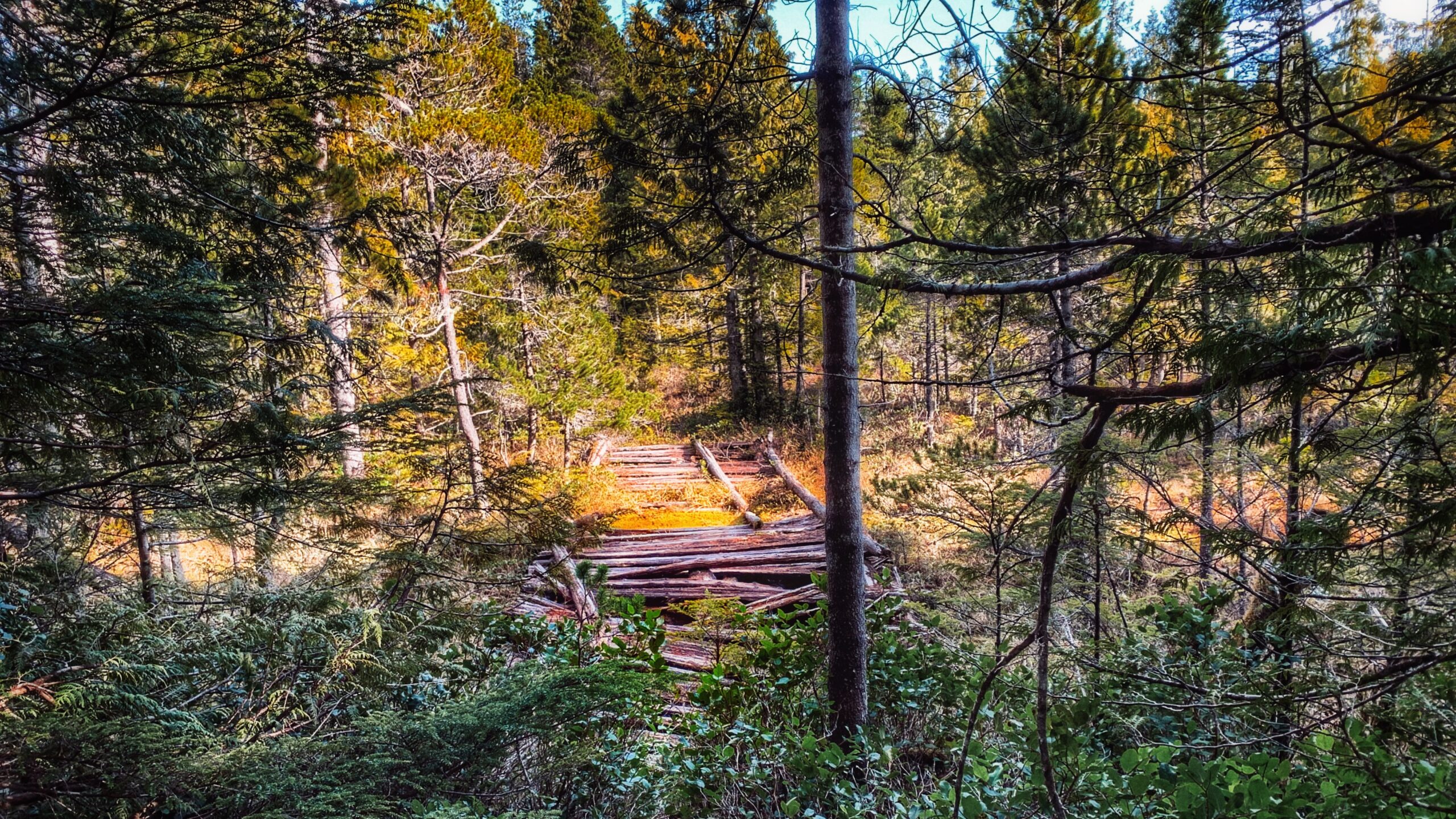
Located within the 2,722-hectare Kamdis Heritage Site/Conservancy, the “Evans Homestead” Trail was first brought to our attention via a series of old photos taken in 1957 by Terry Annis, and posted by Go Haida Gwaii.

The ruins of the homestead, and the promise of massive rhododendrons, were most enticing. Unfortunately, directions towards this unmarked and unmaintained route are sparse.

Nevertheless, while the trail lacks formal upkeep and trail markers, it is still easy to locate and follow with a bit of effort. How do I get to the trailhead? You will find the Evans Homestead trailhead approximately 19 kilometres north of Port Clements, at the end of Nadu Road. Once you arrive at the terminus of Nadu Road, park your vehicle.

You will see two roads side-by-side. The one on the right, which looks to be built on large segments of clay, is used by the Mennonites and is private. You want the overgrown road beside it. This old skid road, once used for logging, represents the official start and trailhead of the “Evans Homestead” hike.

Follow the old skid road for approximately 1 kilometre. After hiking for about 15 minutes, you’ll have to use a natural log bridge to cross the Nadu River on your LEFT. It is important to keep a watchful eye for the crossing because the trail actually continues on past it to the mouth of Nadu River and Masset Inlet. On the plus side, if you do miss the turn-off and hike to the river’s mouth (as we did), you’ll be treated to a unique-looking old-growth cedar tree!

After crossing the log bridge, follow the trail out towards Masset Inlet. It’s clear someone uses this area as an access point because, when we hiked the route, a small table was set up near a skiff. Perhaps the boat is used to access nearby Kumdis Island?

Anyway, it’s at this point you’ll observe the first major piece of colonial history: An old rotting dock which, because of the moss and small trees growing on it, has become quite photogenic. At one point, from this dock, you could walk approximately 1.6 kilometres up an old road towards the remains of a peat moss plant (opened in 1967, after Bering Industries spent $1 million building it, it closed barely a year later).

Unfortunately, when we visited in June 2021, this part of the trail was marked as “closed” – probably due to the extreme overgrowth and lack of upkeep.

From the old dock, walk south along the beach and shoreline for 20 minutes and you’ll eventually come upon the ancient stone breakwater. After 110+ years, only a tiny portion has collapsed, speaking volumes as to the skill, care and craftsmanship that went into building structures at this site.

Finding the actual homestead site proved to be a little tricky, though. We knew the short trail up to the Evans Homestead was near the breakwater, but couldn’t pinpoint where exactly. We ambled around the breakwater for a good hour and a half pondering our next steps.

One of our team members eventually decided to explore the hillside behind the breakwater. He
returned after 15 minutes and reported that it was “nice and flat” up there but “just turned into a big swamp.”

His wife made her way up the steep and muddy embankment and discovered: The “big swamp” was what we were looking for! Thus, we scrambled up the muddy embankment!

As it turns out, the flat, slightly swampy area is the Evans Homestead: Here you will observe 100+-year-old rhododendron trees and remnants of the homestead originally built in 1911 by Edward Evans. From a historical perspective, the site is a real treat to visit and gives you a small taste of what early pioneering life must’ve been like.

While not many remain, the effort left behind impressive stonemasonry and beautiful rhododendrons. If you’d like to see the rhododendron trees in bloom, we’d recommend visiting this area in June or July.

Note: The beach section of this hike MUST be completed on a low or receding tide, so be sure to check the tide tables if you wish to reach the homestead.

DIFFICULTY: Easy
TOTAL DISTANCE: 4 kilometers (return)
TIME: 2 hours
TYPE: Out-and-Back
ELEVATION GAIN: Minimal

NADU HOMESTEAD TRAIL FEATURES
·       Bog environment
·       Settler remnants
·       Harvesting

ABOUT

We first became aware of the Nadu Homestead Trail thanks to “Backroad Mapbooks” (physical maps available at the Daajing Giids Visitor Centre). Really, if BRMB didn’t indicate the location of trails on Haida Gwaii we’d probably miss most of them because a good number don’t have any official signed trailheads. Of course, even with the guide, some trails can be a bit tricky to locate.

The trail is a case in point. When we learned of this route, I recall thinking, “huh? We’ve driven by Nadu Road and don’t recall seeing a trail just off the highway!”

The Nadu Homestead Trail – an old settler wagon road – is located approximately 20 kilometres east of Port Clements, heading towards Masset. Once you see the intersection for Nadu Road, you’ll know you’re in the right place – the trail is direct across the highway. 
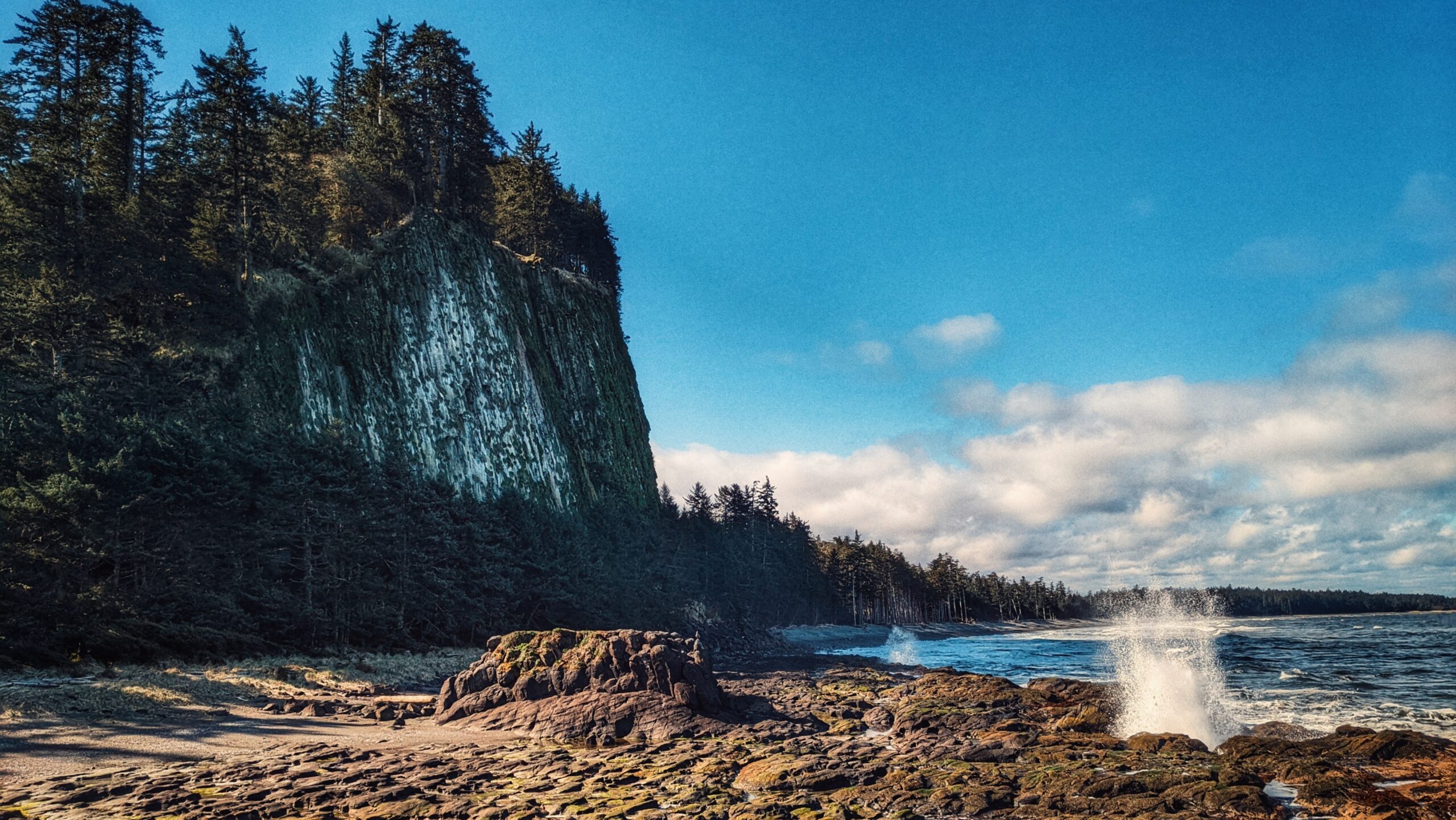
Unfortunately, there’s no real parking available; so, if you wish to hike the trail, we’d recommend parking on the side of Nadu Road and then walking across Highway 16 to the trail. There is no formal trailhead marker, but you should be able to see the trail partially obstructed by thick salal.

Once you push your way through the thick salal bushes, the trail opens up into a visible wagon road. From here on out, the trail stretches just over 2 kilometres one-way and takes you through a unique bog environment and some old-growth corridors. Navigating the bog can be a bit delicate and very wet, so make sure you have waterproof footwear and be mindful of where you tread so as not to disturb the flora endemic to the area.

As we hiked the route, it became readily apparent that the trail is scarcely used anymore. There’s little in the way of markers along the trail; however, this shouldn’t dissuade potential hikers. The route is literally a straight line, so it’s difficult to get lost. Just make sure you don’t stray from the trail because parts are extremely overgrown and one could get easily disoriented.

The Nadu Homestead Trail essentially comes to an end at an old dilapidated bridge. While it is possible to cross using some creative techniques, we don’t feel it’s worth the effort (and risk) because the route ends a few minutes later, anyway, at what was likely the Hendersen homestead.

Why would one wish to hike this trail? Well, there’s the historical aspect: it’s an old settler wagon road, built circa 1910, to access parcels of land further inland. As such, you can see remnants of this early effort to “develop” Haida Gwaii: The clear evidence of the wagon road itself; the hand-dug ditches along the wagon road; old corduroy bridges (especially at the bog); and, vestiges of settler homesteads.

Indeed, it’s not difficult to use one’s imagination and transport yourself back to the early 20th century and picture ye olde horse and buggy ambling about these old roads!

Beyond history, the Nadu Homestead Trail also offers an opportunity to explore and experience unique flora: Labrador Tea, Cow Berry, bog rosemary, cloudberry, and fairly slippers, amongst a whole host of others, call this area home.

DIFFICULTY: Easy
TOTAL DISTANCE: 4.2 kilometers (return)
TIME: 2 hours
TYPE: Out-and-Back
ELEVATION GAIN: Minimal

ONWARD POINT TRAIL KEY FEATURES
·       Whale-viewing
·       Beach access
·       Gazebo

Located on Moresby Island, and approximately 10 minutes from the Kwuna ferry landing, the Onward Point Trail represents a leisurely, brief hike – just over 5 minutes one-way – to a beautiful cedar gazebo.

While at the gazebo, gaze out towards Skidegate Inlet and view the mighty seagulls as they dive for food; the abundant seals as they float about and cause mischief; and the graceful eagles as they soar overhead. If you’re lucky, you may even spy a grey whale or an orca in springtime. 

After spending some time admiring the flora, continue along the loop back toward your vehicle.

Indeed, the Onward Point Trail is pretty straightforward. Once you reach the trailhead, you’ll observe signage identifying the route as “moderate difficulty.” 

We think this is only partly true. As you begin your hike, you’ll immediately notice that the trail splits into a Y (the loop). We recommend going counterclockwise – to the right – as it’s the easier route. There is some deadfall along the way, but the trail is relatively flat and takes you through some nice spruce, ferns and cedar trees. 

If you continue along the loop, from the gazebo, the trail does increase in difficulty but only because the earth is soft in some areas. If you wish to avoid this, simply go back to the way you came.

The Onward Point Trail is a nice break from modernity and offers a serene moment for reflection, thanks to the gazebo and the presence of fairy slippers in spring. If you wish to explore the rocky beach below, there is an informal trail leading down to the beach from the gazebo; however, use caution because the rocks below are often slippery.

Please note the Onward Point Trail does connect with the “Around the Pond” trail extension. If hiking the Onward Point loop counterclockwise, you’ll see the trail to your right about a minute or two into your hike.

DIFFICULTY: Easy
TOTAL DISTANCE: 400 meters
TIME: 10 minutes
TYPE: Loop
ELEVATION GAIN: None

  • Tow Hill
  • Blow Hole
  • Tow Hill
  • Two Hill

TRAIL FEATURES
Haida legend
Basalt rock formations
Unobstructed views


ABOUT

Probably the most quintessential and well-known of Naikoon Provincial Park’s attractions, the Tow Hill and Blow Hole Trails hiking routes are easy and family-friendly, thanks to boardwalks that go their entire length. At the trailhead, which is approximately 26 kilometres east of Masset, you’ll be greeted by two small Haida totems, both of whom sit on either side of a large infographic. This interpretive panel helps set the context for the hike you’re about to embark on.

It enunciates important cultural, historic and environmental information. Notably, and keeping in line with the “accessible” theme, the information board includes colour contrasts and braille. The images can also be “read” with your fingertips.

From the trailhead, hike a little over 200 meters along the wide, hard-packed dirt path. Along the way, you’ll come upon another important feature: A four-track solar-panelled talking sign: Hear a traditional Haida welcome, a Haida song, and the legend of the “Big Spider.”

Indeed, this network of trails – perhaps more than any other on Haida Gwaii – does much to entrench you in this space and this place; that is, Haida territory.

Once you hit the beautifully constructed boardwalk – a partnership between Parks and Old Massett Village Council – you have two options: A hike up to the Tow Hill viewing area (just over 900 meters) or a hike towards the beach and blow hole (just over 700 meters). Each trail, from this point, takes approximately 30 minutes and 15 minutes, respectively.


Tow Hill Trail

Steeped in Haida lore, Tow Hill, or Taaw Tldáaw, is a magnificent volcanic plug formed from eruptions of molten lava some 2 million years ago. Jutting out of the ocean, it is, unquestionably, the most distinguishing geographic feature of Naikoon Provincial Park. Standing at nearby Agate Beach, or North Beach, it dwarfs you with its size; in fact, you can even see it off in the distance while hiking White Creek or enjoying the epic Tl’ellan to Old Massett beach route. Because of its prominence in literature and advertising, Taaw Tldáaw is an iconic image and is synonymous with Haida Gwaii.


Besides its awe-inspiring natural beauty, and deep connection to Haida lore, Taaw Tldáaw and the surrounding area also make for some of Haida Gwaii’s best hiking. Once you reach the boardwalk, go LEFT to continue hiking toward Tow Hill’s zenith.

As noted, the hike is easy, but the incline does increase the higher you go. Along the way, you’ll cross over some minor boggy sections and luxuriantly green moss-covered trees. Take your time to fully appreciate the natural and supernatural beauty of Haida Gwaii as it surrounds and enchants you with its lush rainforest, light mist and heavy cultural traditions.

At about the mid-way point, you come upon the first viewing platform. From here, you can look out onto North Beach, towards Rose Spit – another place steeped in Haida tradition. Once you reach the summit of Taaw Tldáaw, take a moment to breathe in the fresh sea air. From your perch, some 125 meters high, you can see Agate Beach below; the expanses of Naikoon Provincial Park; Dixon Entrance; and, on a clear day, even the shores of Alaska.

Be warned, though, that it is generally quite windy at the top of Tow Hill – something clearly in evidence by the wind-swept trees just outside the viewing platform! Once you’ve had your fill, descend the trail until you come upon a connector to the Blow Hole.


Blow Hole Trail

For our purposes, let’s assume you’re starting your hike from the Tow Hill/Blow Hole trailhead. Again, walk about 200 meters alongside the Hiellen River to the boardwalk. This time, go RIGHT towards the Blowhole. The hike is short – about 15 minutes – and provides some nice ground-level views of the Hiellen River, Christian White’s monumental pole, and North Beach. Lush mosses and a fairly dense forest greets you opposite Oceanside.

Once you reach the end of the short Blow Hole Trail, you’ll find detailed information boards on the origins of “Tow” and how he separated from his brother “Towustain.” The Haida history we’re privy to at this site – combined with nearby Rose Spit and Hiellen – enriches the overall experience and improves our appreciation of this mystical place. In this regard, Tow Hill and the surrounding area are a definite “must-visit” on Haida Gwaii.

Descending the stairs from the boardwalk, you’re treated to a magical space: A coastline covered in lava rock formations, imposing rock cliffs and intense wave action, battering the shoreline. On a rising tide, you will see the “blow hole” in action – a truly special sight! A word of caution: We advise that you steer clear of the rock’s edge on stormy days. The waves are larger and stronger and it is not uncommon for the odd rogue wave to hit this area.


DIFFICULTY: Easy
TOTAL DISTANCE: 2 kilometers return (Tow Hill); 1.8 kilometers return (Blow Hole)
TIME: 1.5 hours
ELEVATION GAIN: 125 meters


St. Mary’s Spring Trail Features
-The fresh water spring
– Escarpment trail

ABOUT

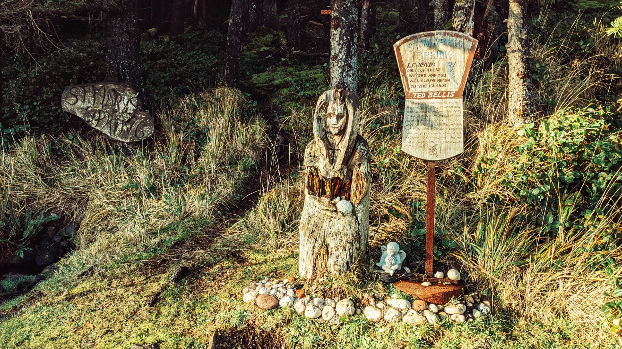
Unlike most places on Haida Gwaii, St. Mary’s Spring Trail is quite young in terms of its history. At the beginning of the 20th century, this area was known as “Duncan’s Well,” named after an early homesteader. 

It is said that travellers used to stop and re-hydrate their horses at the small well. Beginning in the early 1920s, however, Annie Richardson took it upon herself to name the spring after one she’d known in England – St. Mary’s. The wooden carving that is most associated with this spot was carved a few decades later.

Time has not been kind to Haida Gwaii’s wooden saint. Now, when you visit St. Mary along Highway 16, she looks a bit tired and weathered. Her cloak is starting to decay and both arms have rotted away. 

It’s only time before old St. Mary is returned to the earth from which she sprang. It’s sad but, in a way, is reflective of Haida Gwaii: When poles are carved, or houses made, they’re fresh and vibrant.

They give life; however, with the passage of time they, too, grow tired and eventually return to Mother Earth. Such a cycle is actually pretty beautiful if you think about it.

Despite having seen better days, St. Mary’s Spring is still quite attractive. People will visit, lay gifts at Madonna’s feet and drink from the freshwater well nearby. Signage beside St. Mary suggests that those who “Drink of these waters [. . .] will always return to the islands.” It’s a pleasant contemporary legend, though we would note that it’s “drink at your own risk” because the water is untreated and there’s a written notice stating as such.

You will also notice a trail to the left of St. Mary. This is the “St. Mary Spring escarpment trail,” so it is fairly steep (with an elevation gain of approximately 40 meters at its zenith), and goes towards Lawn Hill. The trail markers are scant and poorly done, but the trail itself is easy to follow. As you climb the escarpment, you will encounter dense forest, thick mosses (home to fairy slippers in Spring), ferns and plenty of deadfalls. 

The trail is single-track and narrow. Parts of it are perilously close to the edge and one misstep could result in significant injury. An old blog write-up indicated nice views of Hecate Straight could be had from the trail but, while that might’ve been true at one time, it’s not the case any longer.

Of course, the trail is not the primary attraction; it is the wooden carving. If you visit, we’d suggest posing for a photo beside St. Mary and then admiring the black basalt rock formations across the road.

They hint at some old geologic activity! And, hey, you can also get some nice views of Hecate Strait 😉

DIFFICULTY: Moderate
TOTAL DISTANCE: 3 kilometres (return)
TIME: 2 hours
TYPE: Out-and-Back
ELEVATION GAIN: 40 meters

Rock Sitting Creek Feature:
Easy access to waterfall

ABOUT

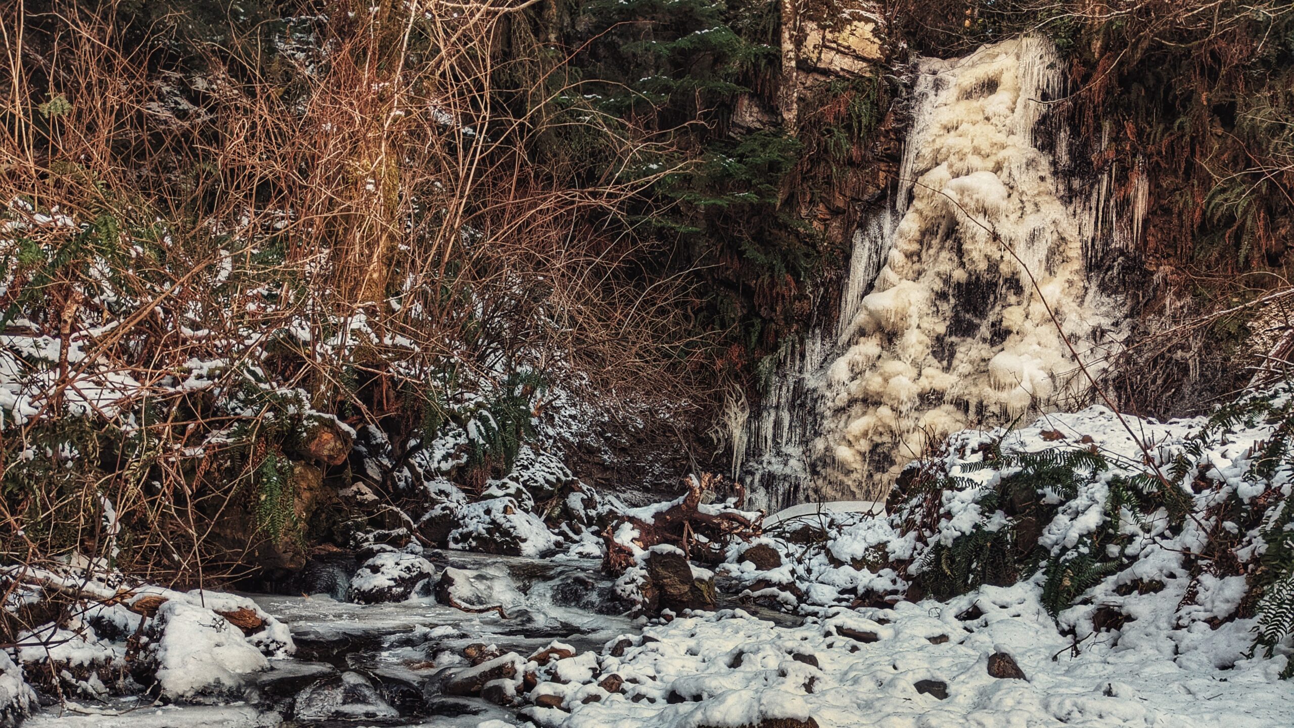
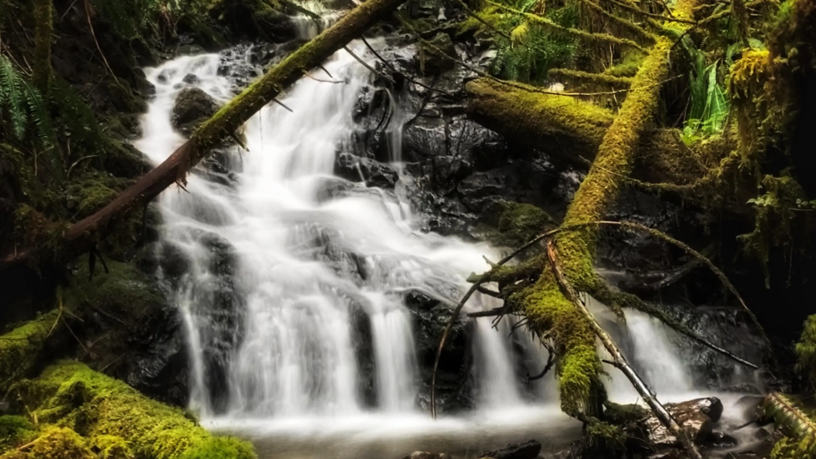
HlGaa K’aayhlina Gandlaay, or Rock Sitting Creek, is something of a hidden gem hiding in plain sight – as it features Rock Sitting Creek Waterfall along its path.

Because of its close proximity to the far more popular Balance Rock, this little waterfall is often overlooked. And that’s unfortunate because the water cascading down the rock cliff can be impressive – especially after a significant amount of rainfall.

You can certainly take some awe-inspiring frozen waterfalls photos in the winter months when the creek freezes in negative temperatures. Summertime does not showcase Rock Sitting Creek Waterfall flowing abundantly as it usually dries up to a trickling sight.

Not many locals are aware Skidegate has this waterfall or most likely just have passed it by following one of the village roads close to Highway 16. The waterfalls are usually overshadowed by either the Spirit Lake Trail or the nearby Balance Rock at the beach.

Accessing this waterfall is easy. If exiting Skidegate and heading north towards Masset, drive past Balance Rock. Shortly after passing the famous glacial erratic rock, you’ll come upon Balance Rock Road on your LEFT. Turn onto Balance Rock Road and, as you round the slight corner, you’ll see a small pullout and signage indicating the waterfall.

Up until the end of 2021, you had to walk a short trail of about 30 meters to reach the waterfall. Early in 2022, however, village maintenance cleared the bushy terrain and essentially eliminated any evidence of a formal trail. Now one could easily see the waterfall from the small parking area; or, if you wish to get close, simply walk the cleared terrain up to the magnificent Rock Sitting Creek Waterfall.

While the short trail might now be a thing of the past, the sublime roar of the falls still beckons and calls to those who chase waterfalls.

DIFFICULTY: Easy
TOTAL DISTANCE: 60 meters (return)
TIME: 2 minutes
TYPE: Out-and-Back (when trail existed)
ELEVATION GAIN: None

  • Blackwater Creek Waterfall Trails
  • Blackwater Creek Waterfall Trails
  • Blackwater Creek Waterfall Trails

BLACKWATER CREEK WATERFALL TRAILS FEATURES:
· Relatively easy access to waterfalls
· Challenging rope sections

The Blackwater Creek Waterfall Trails are a couple of hidden gems on Haida Gwaii. The two trails are short – clocking in at about 200 and 400 meters respectfully – and very remote; however, if one enjoys chasing waterfalls, these two routes are definitely worth the effort. As these trails are not well known, they do not appear in any of the literature available on Haida Gwaii. Here’s how you get to them:


1) Starting in Port Clements, drive south along Bayview Drive towards the Golden Spruce Trail.

2) Keep driving. Bayview Drive eventually turns into the Port Man Forest Service Road – an active logging road. At about the 11km mark from Port Clements, you’ll come upon signage for the “HAIDA CANOE” Trail. Then, 150 meters from this point you’ll spot a “Y” or split in the road. Turn RIGHT onto the New Mainline Road. You will then cross a bridge over the Mamin River before coming to another “Y.”

Keep left on the New Mainline Road for approximately 500 meters. You will then see a minor logging road to your LEFT. Turn here and drive for nearly 5 kilometres. Note that, from this point on, the road is narrow (single track) and does have a few low-hanging alder trees you’ll have to clear.

3) After driving along the road for nearly 5 kilometres, you’ll cross a small bridge over Blackwater Creek. Barely 100 meters past this bridge, you’ll come upon another “Y.” Turn RIGHT. Drive approximately 2 kilometres along this narrow road. If you’ve made it this far, you’ll spy the trailhead marker for the first waterfall. It is signified by pink and orange flagging tape hanging from young spruce trees.

The trail is short – approximately 200 meters one-way – but it is more reminiscent of a stroll through the bush than an actual trail. Expect to walk through dense forest, a lot of deadfalls and a few muddy sections. The good news, though, is the route is extremely well-marked: There is bright flagging tape every few feet, so it’s virtually impossible to get lost.

At the end of your hike, you’ll come upon a moderately steep section, which you must carefully descend in order to view the waterfall. The waterfall itself is quite nice; however, it is difficult to photograph on account of being obstructed by large logs. After enjoying the cascading falls and the sounds of nature, return the way you came.

4) To view the second waterfall, continue driving approximately 1.2 kilometres up the same narrow road. You will eventually see the trailhead markers – signified by candy cane patterned flagging tape – to your LEFT. A pullout, large enough for 2 vehicles, is just a few feet up the road. Unlike the first waterfall, the route to this second waterfall resembles a more traditional trail (albeit a little rough).

It, too, is extremely well marked with flagging tape. The total length of this trail is approximately 400 meters (one way), but that’s because, at the mid-point, it splits. If you go to the RIGHT, you’ll come upon the “top” of the falls, which is picturesque in its own right and features an attractive “kiddie pool” more than suitable for a swim.

If you go to the LEFT at the trail split, you’ll eventually make your way to a fairly large waterfall, cascading down a rounded rock face. Use caution, though: To get to these falls, you must descend an extremely steep area that, in one area, is almost completely vertical. There are several sturdy ropes to assist you here. Once you make it down, however, it is only a short walk to the impressive falls.

It is not uncommon for people to linger here for many a moment and cool off under the cascading water. Once you’re finished admiring the serene beauty laid out before you, simply head back the way you came.

Getting to these waterfalls may be tricky (both in navigating the narrow logging roads and hiking), but it is well worth the effort. In both instances, the waterfalls are a mere 10 to 15 minutes off the road. In our view, the second waterfall, in particular, is the major highlight because of its size and relative ease of access; in fact, we’d even suggest it rivals the Dover Falls in Sandspit!


Again, though, keep in mind that you will be driving on active logging roads; thus, proper caution should
be exercised. In addition, while a truck is not necessary to reach these sites, a standard vehicle is not ideal for these roads.


DIFFICULTY: Easy to Moderate
TOTAL DISTANCE: 400 and 800 meters (return)
TIME: 50 minutes (for both trails, out and back)
TYPE: Out-and-Back
ELEVATION GAIN: Minimal