


Cape Fife Trail Features:
East Beach Access
Old growth forest
Overnight shelter
Settler remnants
Board walk trail parts
ABOUT
Cape Fife Trail was established circa 1910 as a settler wagon road to access parcels of land and serve as an important lifeline and access point to East Beach. The wagon road originally started slightly north of the current marked route and terminated at Kumara Lake. The trail now known as Cape Fife was cut in 1972 by the Masset Lions Club, though it does connect with – and follow – large sections of the original route (the old wagon road is obvious when you’re walking on it). At just over 11km one-way (signage says 10km, but this is wrong), it is a long but relatively easy hike with very little elevation gain.
As you hike this route, you will encounter varied landscapes: Rich forest, delicate bogs, intricate sand dunes and endless beaches. Taken as a comprehensive whole, Cape Fife offers a little something for everyone. Whether you choose to hike the whole route, part of it, or camp overnight at East Beach, is entirely up to you. In brief, you can make the hike whatever you’d like it to be.
LOCATING THE TRAILHEAD
The Cape Fife Trail is one of the few signed and marked routes on Haida Gwaii. To access the trail, drive north to Naikoon Provincial Park towards Taaw (Tow Hill). Park your vehicle at the Tow Hill parking lot. From here, walk across the Hiellen River Bridge You will see the Cape Fife trailhead to your right. Thus you now begin your epic hike toward Haida Gwaii’s East Beach!
HIKING THE TRAIL
The Cape Fife Trail begins on the north side of the Hiellen River and is mostly flat and level the whole way. After hiking for about 5 minutes, you’ll come upon a wide open space and a fork in the trail. Cape Fife continues to your LEFT (going right will take you onto the Four Corners). Before continuing, we recommend studying the Cape Fife information board also found in this area. It outlines the route and highlights a couple of key features – study it to ensure you’re adequately prepared for the hike.
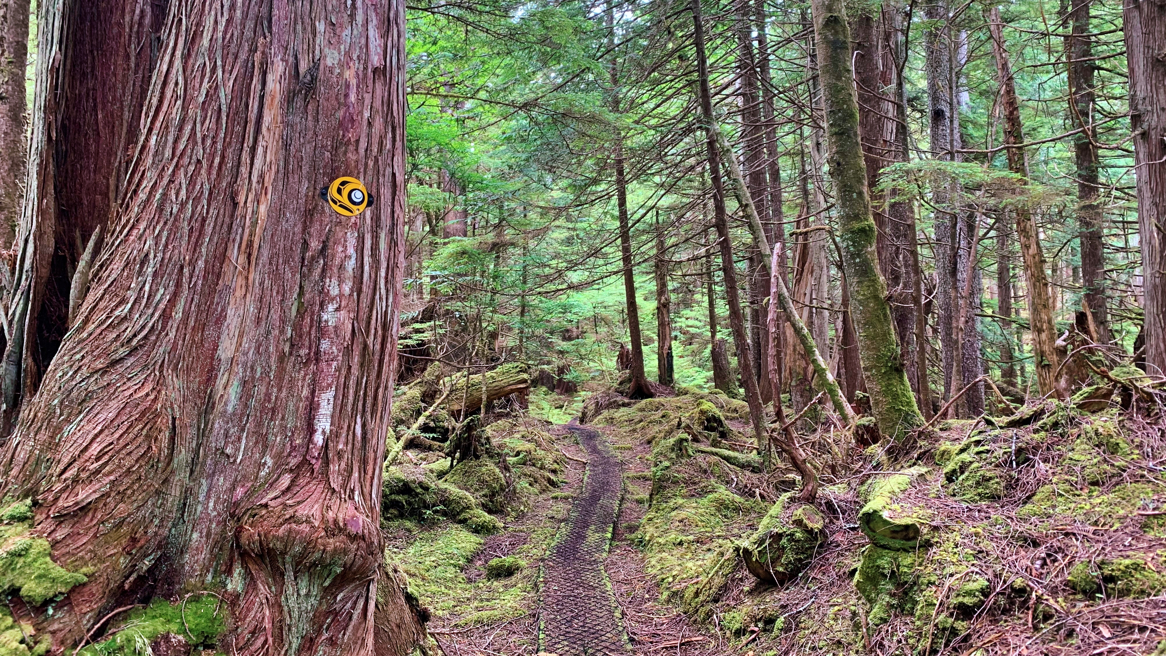
The first 4 kilometres take you through a beautiful forest environment, including old-growth cedars, hemlock and pine. Thick mosses of various shades of green carpet on the ground and strategically placed boardwalks help navigate a number of potentially miry sections. After clearing the forest, you enter the bog ecosystem and begin crossing the Argonaut Plain.
If you’ve hiked other bog trails on Haida Gwaii – White Creek, Nadu Homestead or Boulton Lake, for example – you know they can be tricky on account of the delicate and wet ground. Thankfully, you don’t have to contend with that too much on the Cape Fife Trail because boardwalks and stepping logs line the route; however, we recommend still using caution because a number of the boardwalks in this area are old and in need of repair or replacement.
In addition, the trail, at this point, has a lot of roots jutting out of the ground – and this goes on for at least a few kilometres – making parts of the hike a little more challenging. Nevertheless, just watch your step and enjoy the bounty of Labrador tea that surrounds you.
An aside: Henderson (1978) notes that at the 5-kilometre mark, on the north side of the trail, a flagged route will take you to Mica Lake in approximately 15 minutes; at the same point, but on the south side of the trail, there are remnants of a homestead. In the 45 years since those words were written, the flagging tape is gone and we did not notice any homestead remnants at this point; however, the ditching, which was all done with pick and spade, is still very much in evidence along various sections of the Cape Fife Trail. We suppose one could still hike to Mica Lake, but be sure to have a compass or directional app with you.
At about the 7km mark you can hear the waves of Hecate Strait in the distance. The trail also begins a slow descending pattern as you make your way toward the beach. While this part of the trail is mostly clear, roots represent the most significant and sustained obstacle. There is also one area that requires you to get on your knees to crawl under some deadfall.
As you close in on Cape Fife, you descend some stairs and enter the home stretch! These last few meters, though, are covered with long beach grass, obstructing the trail from view. As such, use caution: It’s difficult to see what you’re stepping on and thus represents a tripping hazard. Once you clear the long grass, you are at the Cape Fife shelter!
The Cape Fife shelter was a joint initiative between the Haida Nation and BC Parks. It is built in the traditional longhouse style and contains all of the amenities one could want for a brief break (if hiking Cape Fife as an in-and-out route), or to camp overnight: 4 bunkbeds, wood stove and a small table with a guestbook. An outhouse and a couple of hammocks are also available on-site. Curiously, cellular service is also available here. Kumara Lake, the original terminus of the wagon road, is also visible about one-hundred meters north of the shelter.
Once at the shelter and East Beach, you might wonder “Why Cape Fife?” because there is no “cape” at the trail’s end or within the immediate vicinity. The simple answer is “time.” After years of erosion from the powerful waves, the “cape” that once jutted out here has fallen to the sea.
From Cape Fife, you can simply go back the way you came or make this a much longer hike by walking up East Beach towards the beginning of Rose Spit (roughly 8km) and then hiking south back towards Taaw (roughly 18km).
While Cape Fife is generally an easy hike, its length makes it challenging for some. Allow anywhere from 4 to 6 hours to complete the hike one-way and be sure to bring plenty of water and snacks. The route is well-delineated with a combination of orange triangles and Ben Davidson’s trail marker.
DIFFICULTY: Moderate
TIME: 5 hours (one-way)
TYPE: Out-and-Back
ELEVATION GAIN: Minimal