


Gold Creek Trail Features:
Muskeg terrain and flora
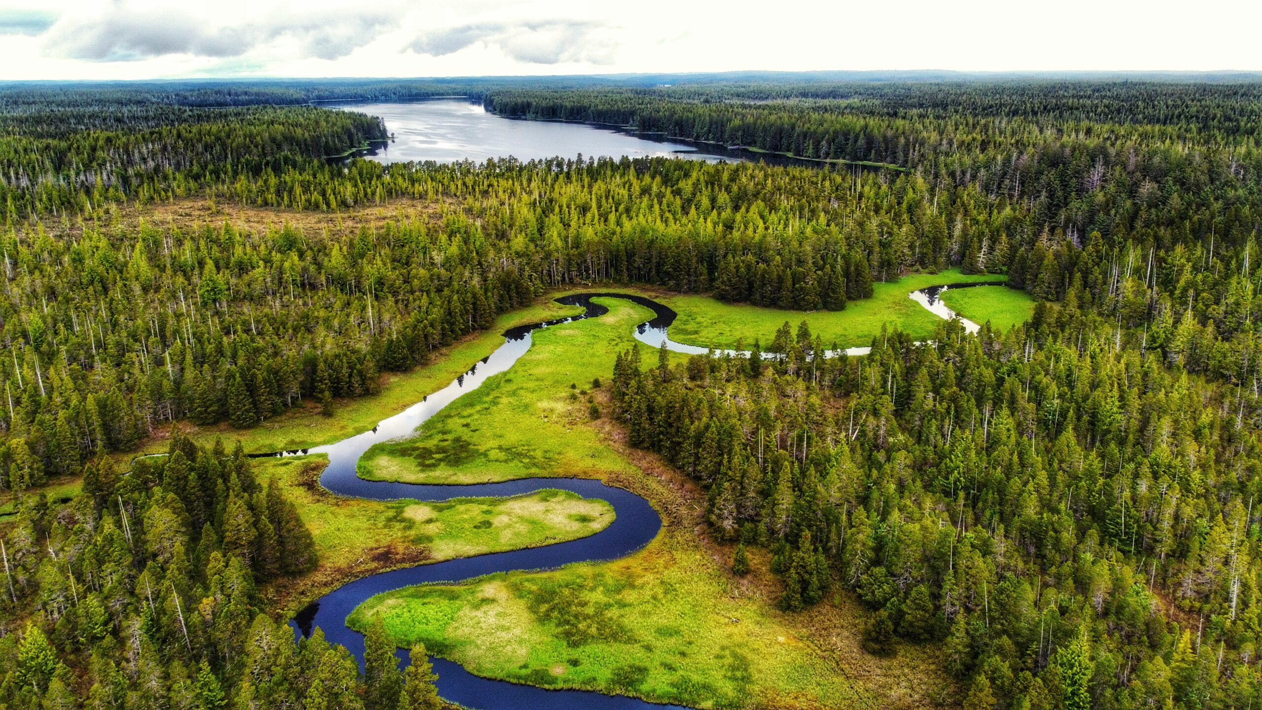
Winding creek
Entry to Mayer Lake
Homestead remnants
NOTE: Gold Creek often floods during the wet season, making the route inaccessible. We, therefore, recommend it as a summer-only hike.
ABOUT
Gold Creek Trail meanders through Muskeg, crosses the highway between Tlell and Port Clements (the old “Mexican Tom Trail”), and eventually flows into the south end of Mayer Lake via the Mayer River. The trail is informal – unmarked – and is typically begun at the Mayer Lake Day Use area; however, we decided to go against the grain and commenced our hike of this informal route at the “Gold Creek” bridge, just along Highway 16.
WHY GOLD CREEK TRAIL?
Unfortunately, you’re not too likely to find any gold along the banks of Gold Creek. According to Dalzell (1973), the name “Gold Creek” is simply a carry-over from the days when the Mayer River – which you’ll also pass by before reaching the south end of Mayer Lake – was called “Gold Creek” after an old prospector believed he’d found gold at the river’s mouth. The ungazetted name was given a bit of official status after the Department of Highways immortalized it on their bridge signage.
THE HIKE
We parked our vehicle on the shoulder at Gold Creek Bridge and started hiking on the west (LEFT) side of the creek. As noted above, the trail is informal and sans marker, but all you have to do is follow the creek until you reach the south end of Mayer Lake. The area around the creek is delicate muskeg, so a good pair of boots or waterproof shoes is recommended.
As you amble about the meandering creek, pay close attention to the fragile environment in which you’re walking: Labrador Tea, Sundews and other bog flora are not uncommon. Quite early on in the hike – at around the 10-minute mark – you will also spy two fence posts, from days gone by, on either side of the creek. We wonder what these were used for.
After about an hour, we reached the “junction” where Gold Creek meets the Mayer River. At this point in the hike, you enter a small forested area before re-emerging at the point where the Mayer River meets the south end of Mayer Lake. As you walk along the shore of Mayer Lake, an actual trail is finally visible. You will also likely notice some deer exclosures on the forested side (to your left). These are quite new, having been installed in 2022 in an effort to restore and protect k’ay trees (Crab apple) – the only native fruit trees on Haida Gwaii.
We concluded our hike at the Mayer Lake Day Use Area just as the sun was setting. The serene calm was interrupted by a beaver splashing its tail in the lake. To save time, we walked back along the dirt road and along the highway to our vehicle at the Gold Creek Bridge.
Of course, most people who choose to do this hike are more likely to begin at the Mayer Lake Day Use Area. In that case, once you reach the Gold Creek Bridge, you can simply return the way you came or walk back to the Day Use site via the Highway. Regardless of where you begin, we encourage you to take your time along the banks of the creek: The environment is so unique and so calm that one cannot help but admire the natural beauty that surrounds you. On a clear day, the waters of Gold Creek resemble that of a mirror!
DIFFICULTY: Easy
TOTAL DISTANCE: 1.8km (one-way)
TIME: 1 hour and 20 minutes
TYPE: Out-and-Back
ELEVATION GAIN: None