


Sleeping Beauty Trail Features
Fantastic viewpoints
Challenging slope sections
ABOUT
The “Sleeping Beauty Trail” is one of Haida Gwaii’s most famous hikes, perhaps only next to the Tow Hill/Blowhole and Golden Spruce trails. With its varied terrain and expansive views, “Sleeping Beauty” should be on every visitor’s bucket list if they’re looking for a challenging yet rewarding hike.
Unfortunately, though, this trail can be a little confusing – at least insofar as finding it. How come? In brief, there is no trail on Haida Gwaii called “Sleeping Beauty.” The name “Sleeping Beauty” actually refers to Mount Slatechuck and Mount Raymond – known collectively as the “Sleeping Beauty Trails” because, when viewed from the Village of Daajing Giids, the mountains resemble a woman’s face when laying in repose. What trail, then, are people referring to when they say they’re going to hike Sleeping Beauty?
Generally, the hike most people are referring to is the Tarundl Trail, which brings you to the summit of Mount Raymond. Of course, if you didn’t know this then locating “Sleeping Beauty” could prove somewhat challenging. And that confusion is merited because the signage for “Sleeping Beauty” can be confusing. We will try our best to reduce this befuddlement.
LOCATING THE TRAILHEAD
To locate the Tarundl Trail / Sleeping Beauty trailhead, follow these steps:
- Drive west through the Village of Daajing Giids along Oceanview Drive until you come upon the intersection to the village cemetery and Haydn Turner campground.
- Turn RIGHT onto the Honna Forest Service Road. Continue driving west for approximately 3.8 kilometers and turn RIGHT 400 meters past the Kagan Bay Recreation Site (you should see a “Sleeping Beauty” sign at this point).
- Drive north for approximately 1.3 kilometers. You should see another “Sleeping Beauty” marker to your LEFT, leading you up a fairly rough and narrow road. Culvert upgrades were completed in early August 2024. A high clearance vehicle is recommended, but standard size vehicles could make it if driving with caution.
- Drive about 3.5 kilometers. You will pass the first “Sleeping Beauty Trails” sign (leads to the Slatechuck Mountain trailhead). Drive just over a kilometer further and you will arrive at a small pullout. You should see the “Sleeping Beauty Trails” marker here. Welcome to the Tarundl Trail!
HIKING THE TRAIL
The Tarundl Trail hike begins easy enough as you cross a small footbridge over Tarundl Creek. The path is grassy, flat and a little muddy. After trekking approximately 100 meters, you will come upon the “Tarundl Tr” marker, which points into a dense and fairly young forest. At this point, the Tarundl wastes no time in gaining elevation – onward and upward!
The climb up is straightforward and exceptionally well-marked with yellow circles and reflective orange squares. You begin by navigating some tree roots before coming upon a series of high steps. In many instances, the dense trees along this section of the trail serve as useful handgrips. After about twenty minutes, you’ll come upon a rough ladder designed to help you up a small, steep section of the trail. From here, the trail continues to climb along a well-worn, albeit muddy, path. Be prepared for a few rope sections and minor blowdown along the way.
We took a hydration and snack break just past the mid-way point, alongside some beautiful old growth cedar trees. Continuing on, the climb up was relentless, but gradual. As you begin entering the alpine, the forest starts thinning out and the trees become more gnarled and stunted. Peering through the trees, you also begin to get nice views of Bearskin Bay and Slatechuck Mountain.
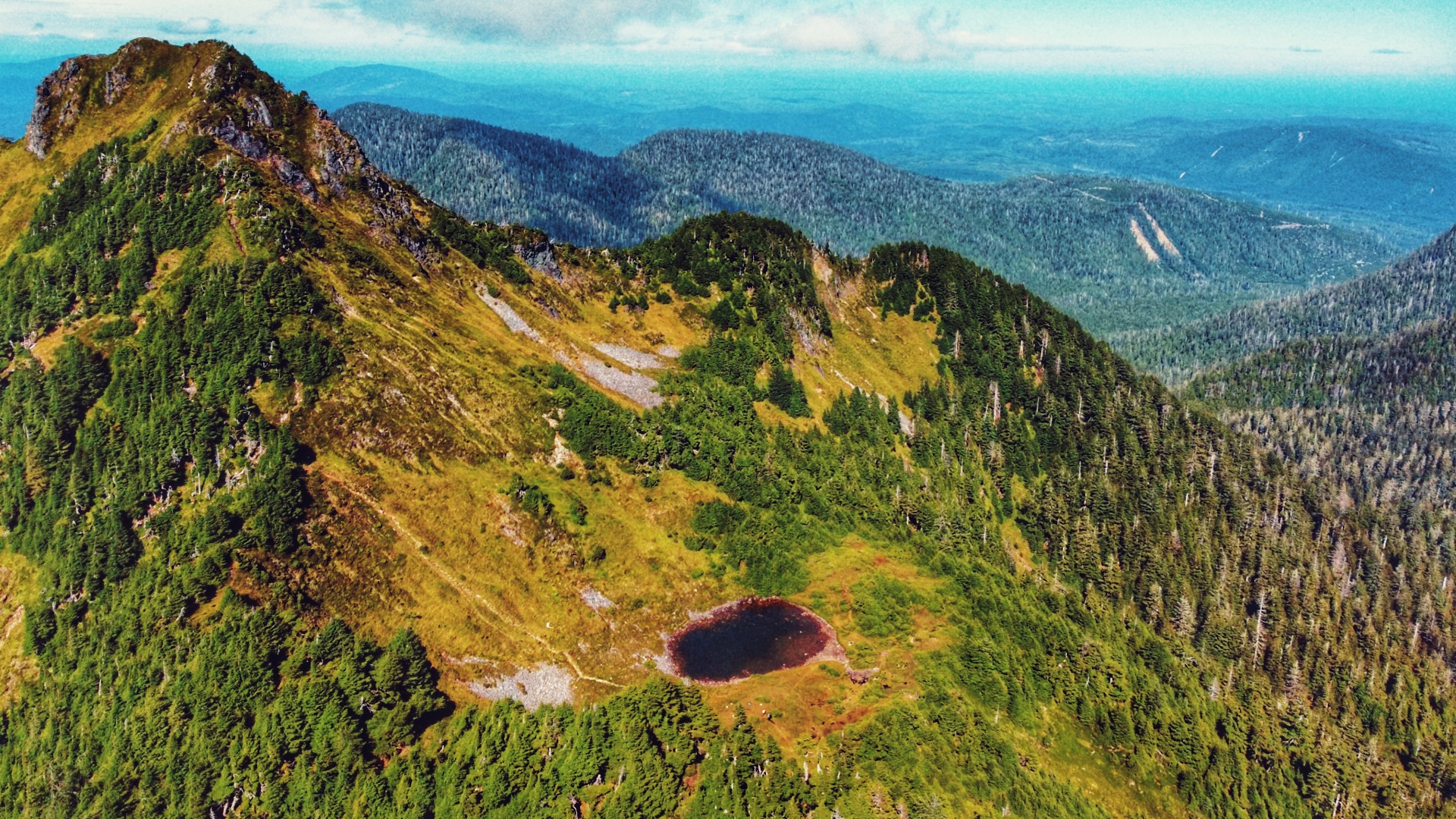
Once in the “final stretch,” as you approach the verdant bowl of Mount Raymond, the trail gets a little more scrambly and harder to follow as the markers thin out. First, you must climb some narrow stone steps. After that, keep an eye out for a rope section that snakes under a fallen tree. We missed this during our ascent and ended up climbing up and over a gnarled tree – only noticing the rope on the opposite side after the fact! From here, climb up a rock face to a very narrow section of trail with only a small rope railing to guide you. Once you clear this, ascend a little further through some gnarled trees and you’ll reach the bowl. Home to the tarn known as “View Lake,” this flat area is a popular place for hikers wishing to camp under the starry night sky.
For those wishing to climb to the zenith of Mount Raymond, and the “nose” of Sleeping Beauty, you will need to trek onwards an additional 15 minutes. The path to the summit is well worn, but very steep. On a clear day, you can expect to see breathtaking views of Rennell Sound, Yakoun Lake, Stanley Lake, Daajing Giids, and much of the Queen Charlotte mountain range. Those wishing to complete a loop trail can walk along the ridge between Mount Raymond and connect to the Slatechuck Mountain trail.
While most report the descent down Mount Raymond to be quicker than the climb, it can actually be more challenging due to loose rocks, mud and the abundant tree roots. Take your time as a wipeout is certainly more likely here! Once back at the trailhead and parking lot, take a celebratory swig of water and enjoy a nice meal back in Daajing Giids!
Note: Cellular service is available for most of the hike, less at the trailhead.
DIFFICULTY: Hard
TOTAL DISTANCE: 5.3 kilometers (one-way)
TIME: 3 hours (one-way)
TYPE: Out-and-Back
ELEVATION GAIN: 644 meters