

The mossy parts makes an impressive sight Durant Homestead’s standing cabins 
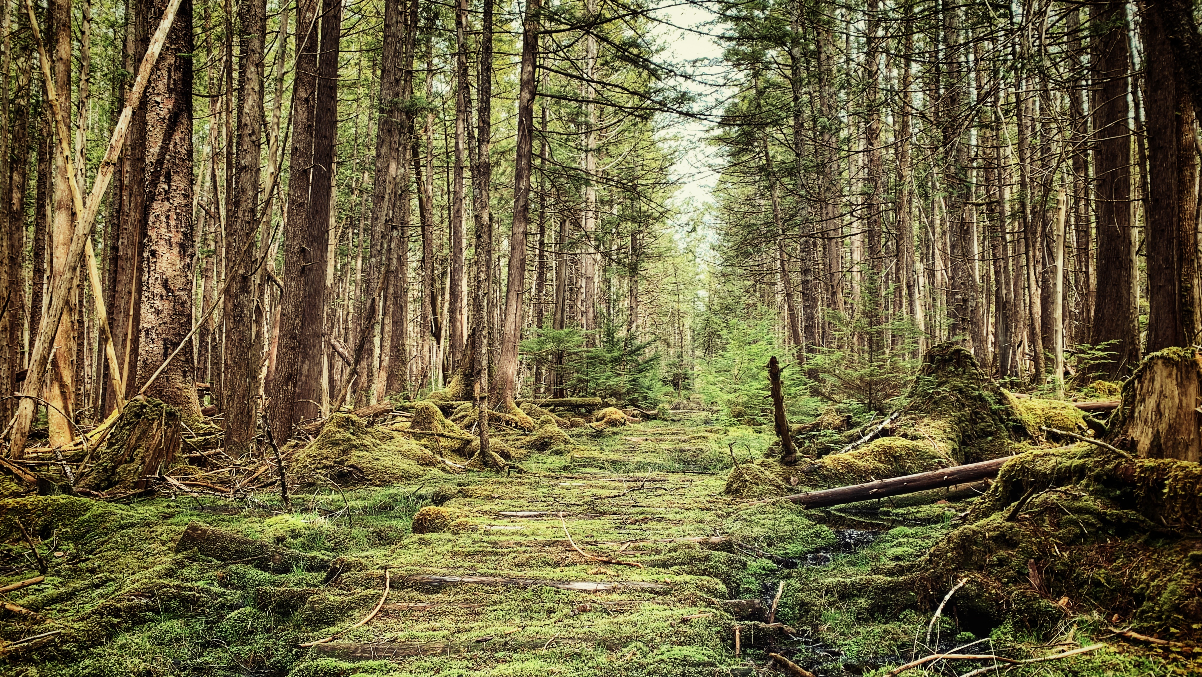
The corduroy walkways are still visible in most parts of the trail 
The Fall walk in the North Road launches a strew of generous patches of mushrooms (Oct 2022) The wagon road that leads to the Inside Road, Pretty John’s, and Pontoons Meadow trails Afternoon hikes also is welcome on a dry day to see the logs walkway This mighty tree deafall points one to the Poontons Meadow Trail


POONTOONS TRAIL FEATURES
Early settler history
Pontoons Meadow
Foraging and hunting
ABOUT
Unlike most trails on Haida Gwaii, the Pontoons Trail actually has a signed trailhead marker. Unfortunately, the trail can still be a little tricky to find, if only because there isn’t much-published information available.
If you pick up the Backroad Mapbook at the Daajing Giids Visitor Centre or download the app, you should have an idea of where the trailhead is. Nevertheless, we’ll endeavour to make finding this unique and epic hike a little easier to find:
Assuming you’re coming from Skidegate, drive roughly 17 kilometres along Highway 16 until you come upon the intersection of Lawn Hill Road. Turn left onto Lawn Hill Road.
Drive down Lawn Hill Road until you cross Lawn Creek Bridge. From here, and directly ahead, you’ll see a joke sign: “Violators will be prostituted.” This rather humorous sign indicates a private property; however, to your LEFT you will see a small yellow sign posted on an alder tree: “OLD WAGON ROAD.” This sign essentially signifies the start of your hiking adventure, but it is not the trailhead.
If you have a truck, it is possible to drive approximately 1 kilometre up this old road but, if you don’t, then we strongly recommend hiking it. There is some minor incline and fairly deep potholes along the way.
After you’ve walked or driven the 1 kilometre, you will see some blue and pink flagging tape to your RIGHT and a small footbridge. Cross this bridge onto a wide, but not the too obvious path. You should see the trailhead marker for the “Pontoons Wilderness and Historic Interpretive Route” straight ahead (and the trailhead marker for the Prettyjohn’s Trail route to your left).
From the trailhead sign, continue walking north. You are now en route to the Pontoons! It’s little wonder most people have difficulty finding this route or are completely ignorant as to its existence. In the current day, the trailhead isn’t exactly easy to find unless you already know where it is.
Difficulty in locating the trail aside, what makes this route a “must do” when visiting Haida Gwaii? In brief, you’ll want to hike this wild and remote route because it’s an immersive experience.
The full Pontoons trail is approximately 9 kilometres one way. Along the route, you get to experience settler and natural history; Haida culture; envelop yourself in outstanding examples of old-growth Sitka Spruce, Western Hemlock, Red Cedar, and Riparian forest; and, of course, explore the unique fen and marsh complex that makes up the Pontoons.
Because the Pontoons hike is so rich, we will divide it into three manageable “chunks.” Two of the three “chunks” can be completed individually, as separate hikes in their own right: 1) The North Road; 2) Durant Homestead; and, 3) The Pontoons Meadow.
The North Road Trail

Once you reach the Pontoons trailhead marker noted above, you’ll officially be on the North Road which, as the name suggests, basically runs north for about 4 kilometers before turning west (or LEFT, if you prefer that term) towards the Pontoons Meadow.
This section of the hike is an old wagon road developed in 1910 as part of a government strategy to encourage settlement in the area. The land was sold for cheap, but living here wasn’t easy.
Much of the designated farming land was originally muskeg and therefore incredibly low in nutrients. A lot of hard work went into making the land arable; however, because of the challenges faced, most settlers were gone by the early 1930s.
In the early 1900s, this route had a lot of small homestead cabins dotting the road, but most of these were abandoned by the end of the First World War. Unfortunately, not many remains of ye olde pioneering spirit today.
There is, of course, the old wagon road itself and, as you hike, you will see and cross some corduroy bridge structures. Besides that, the only other notable evidence of past settlement along this section of the Pontoons trail is the hand-dug drainage ditches, which run along large segments of the North Road.
While the North Road is pleasant to hike at any time of the year, we’ve found it to be especially magical during autumn. As you walk the moss-covered road, its surface comes to life with all sorts of unique fungi, including chanterelles and honeys. It’s a proverbial mushroom picker’s delight.
And the old road, with its towering trees and dense fog, creates an almost magical, otherworldly environment. Indeed, for us, this segment of the Pontoons is the very definition of forest therapy.
After hiking approximately 3 kilometres, you will come upon an active logging road. It is called “Lawn Hill Road North” and is fairly recent, only having been built in the last 15 years. Prior to its construction, the North Road travelled uninterrupted for just over 4 kilometres. This “break” in the trail represents the second “chunk” of the route: The Durant Homestead.
The Durant Homestead

After crossing the logging road, continue north for approximately 1.5 kilometres towards – you guessed it – the Durant Homestead. While part of the North Road, the Village of Daajing Giids has this segment of the old wagon road listed as a separate trail on its Visitor Centre website. Indeed, while we find this kind of odd, it is nevertheless possible to access the “Durant Homestead Trail” by itself.
Unfortunately, the Visitor Centre is wonderfully vague in this regard: “Access old corduroy road [. . .] from 6.5 k on Lawn Hill Road North.” If driving from Skidegate, drive north for approximately 22 kilometres until you see the crudely written “LAWN NORTH MAIN” sign to your left.
When you turn onto this dirt road, be aware that you’re driving on an active logging road, so take the necessary precautions. The road is in decent enough shape that an SUV could probably drive it, but you might “bottom out” on the steep incline near the beginning of the road.
After the initial hill, though, the road remains relatively flat. Drive along Lawn North for 10 minutes, or approximately 5.3 kilometres (the Village of Daajing Giids says 6.5 kilometres, but this is wrong). At this point, you should see the fancy trailhead marker for the Durant Homestead Trail: A stump with some rocks piled on top of it!
From here, the Durant Homestead is approximately 40 minutes, or 1.5 kilometres, down the North Road. While the first part of this trail is quite miry, the rest of it remains in relatively good shape.
There are some muddy sections; parts of the corduroy road are slippery and loose; and, there is some deadfall requiring you to get down on your knees but, for the most part, the trail is easy to navigate and follow.
As you amble about this route, it’s not difficult to transport oneself to an earlier time, circa 1910, when homesteaders were trying to cultivate and develop this land.
About mid-way through your hike, you’ll come upon a sign: “The Great Fire of the 1840s.” Without a bit of context, this might seem rather queer. 20 years ago, the Tlell Watershed Society (TWS) undertook a project of developing/maintain a number of trails in the Tlell Watershed area.
The purpose was essentially twofold: 1) Create awareness of, and protect and conserve the watershed; and, 2) Provide an opportunity for people to experience this unique wilderness through interpretive hiking trails. Signage like “The Great Fire” was posted at strategic points along TWS trails and was originally meant to be accompanied by a short booklet.
Unfortunately, a lack of funds resulted in nearly zero formal upkeep and a good number of these trails – especially Three Mile Creek, Monique Creek and Old Growth Alley – fell into rapid disuse. While some interpretive signage has survived, most have fallen to the elements.
If you’ve kept a keen eye throughout your hike, chances are you will have noticed a number of burnt trees – these are all a result of the “Great Fire of the 1840s.” The cause of the fire remains unknown, but it burned a massive amount of forest from the upper Tlell all the way to Masset.
You will also see evidence of this fire on other trails in the Tlell area: Prettyjohn’s, Old Growth Alley and the Anvil Trail. After walking about 40 minutes from the Durant trailhead, you’ll come upon a large fallen Sitka spruce tree. If you look beyond it, you’ll see signage for the Pontoons – this represents the third “chunk” of our hike. But more on that in a moment.
If you intend to visit the Durant Homestead, look to the immediate left of the fallen tree. You’ll spy a small wooden bridge – follow it a few minutes to the homestead.
As you can see, these structures are modern and still occasionally used by hunters today. Besides the well-constructed cabin, you’ll also see an old outhouse, garden, sauna, and what appears to be a chicken coup on site.
During spring and early summer, the rhododendron bushes are in bloom and make for an impressive site. Before you leave, be sure to sign the guestbook in the cabin!
The Pontoons Meadow

The Pontoons are approximately 3 kilometres, or 1.5 hours, beyond the Durant Homestead. From this point, the old wagon road becomes less evident, but still easy to follow thanks to flagging tape.
After navigating some wet/boggy areas, you will finally reach the Tlell River and Pontoons at the 8.8-kilometre mark. Welcome to the Pontoons Meadow!
The Pontoons, often referred to as the “Heart of the Tlell,” make up the majority of the Tlall Heritage Site/Conservancy. Because it is Haida Gwaii’s only interior wetland ecosystem, numerous moves have been made to protect it, including a failed attempt in the 1980s. In 1996, Survey Creek (a tributary of the Tlell River) and the Pontoons were identified by the Province as “Goal 2 Study Areas” under the Protected Areas Strategy due to their “unique” characteristics.
In 2008, the area was formally protected with the signing of the Haida Gwaii Strategic Land Use Agreement, which stated that protected areas – like the Pontoons – are to be set aside for cultural, spiritual, ecological and recreational purposes. They are also to be maintained for the education and enjoyment of future generations.
After such a lengthy and, at times, challenging hike, the views presented by the Pontoons are a breath of fresh air. Mostly flat and relatively shallow, the Pontoons Meadow is home to a unique wetland environment on Haida Gwaii: Bogs, Fens and Marshes all call this 690-hectare space home. Viewed from above, you can observe all tributaries of the Tlell – less Geikie Creek – converging at the Pontoons.
As a result, the ground is rich in nutrients, contributing to the diverse flora of the area. It is also what attracts the island’s local elk population, introduced in 1929, to the area.
Besides the beautiful natural environment, there’s also a bit of history – or folklore – attached to the Pontoons. Allegedly there was once a & quote “floating barn” on the Pontoons, built for storing hay.
As the story goes, farmers producing cattle allowed their herd to enjoy the grounds in summer; however, because the Pontoons often flood during the winter months, a “floating barn” was created so that, when the Tlell floods its banks, the barn and its cargo of precious hay would simply float up with the swelling river.
The existence of this barn hasn’t been verified, but a structure – possibly the fabled barn – can be found at about the 9.1-kilometre mark.
All in all, the Pontoons Trail is an epic hike on a number of fronts. If you’re feeling ambitious, you can choose to tackle it in one 18-kilometre round-trip swoop, or just walk segments of the route (North Road and Durant).
No matter what you decide, you’ll enjoy old growth and second growth forest; settler history in the form of the wagon road and its associated structures; gain an appreciation of Haida cultural values; and, of course, totally immerse yourself in the beating heart of the Tlell River.
DIFFICULTY: Moderate
TOTAL DISTANCE: 18 kilometers (return)
TIME: 8 hours
TYPE: Out-and-Back
ELEVATION GAIN: Minimal