

Pretty John’s Trail boast of pristine forest parts 
The “Old Wagon Road” trail head One of the many cordoroy bridges in the muddy parts of the trail 
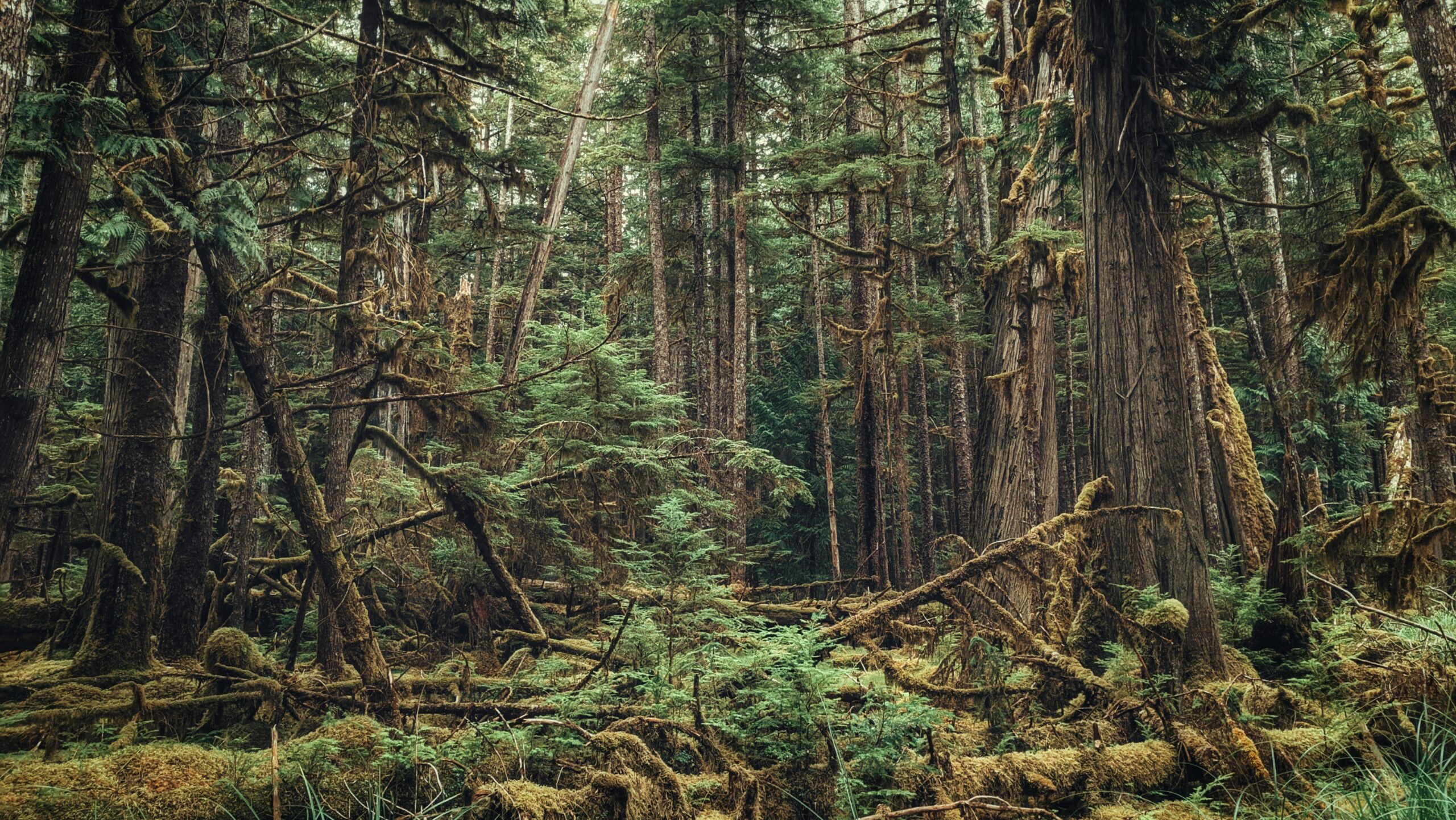
The Great Fire of the 1840s Some parts have endless moss covering the both sides of the path The Pretty John’s Meadow which is pointed as the main camping ground by hidden signage Near the beginnings of Tlell River that leads to the Tlell Falls


PRETTY JOHN’S TRAIL FEATURES
Early Settler history
The Great Fire of 1940s
Tlell Falls
ABOUT
Like many trails on Haida Gwaii, it can be challenging to locate Prettyjohn’s trailhead thanks to the nebulous and sparse literature out there. We shall endeavour to make finding this special trail a little easier:
If travelling north from Skidegate, drive roughly 17 kilometres along Highway 16 until you come upon the intersection to Lawn Hill Road. Turn LEFT onto Lawn Hill Road. Drive down Lawn Hill Road until you cross Lawn Creek Bridge. From here, and directly ahead, you’ll see a rather humorous sign: “Violators will be prostituted.”
This sign indicates private property; however, to your LEFT you’ll see a small yellow signposted to an alder tree: “OLD WAGON ROAD.” This sign signifies the start of your hiking adventure, but it is not the trailhead. Park your vehicle on the side of the road and prepare for your hike!
Begin hiking up this road. At about the 1-kilometre mark, you should see some pink and blue flagging tape to your RIGHT and a small footbridge. This is the start of the North Road and “Pontoons Wilderness Historic Interpretive Route.” If you cross the bridge and walk a few meters, you should also see a trailhead marker for Prettyjohn’s interpretive route to your LEFT.
While this side road is technically the start of the Prettyjohn’s hike, it has fallen into disuse over the last 20 years. Now, the standard practice is to IGNORE the aforementioned pink and blue flagging tape and CONTINUE walking west an additional 500 meters past some dilapidated Vehicles.
After hiking 1.5 kilometres, you will come upon another small footbridge. Cross the bridge and walk up a small hill. You will come upon an intersection in the settler wagon road. While it may be tempting to go left, you’ll actually want to go RIGHT (note the well-worn ATV tracks).
You are now on the Inside Road and on your way to Prettyjohn’s Meadow and the Tlell Falls! Follow the blue arrows for approximately 7.4 kilometres to reach the historic meadow.
“But,” you may be wondering, “why Prettyjohn’s?” Indeed, the name is kind of baffling, but the route is named after William Prettyjohn, one of the first British settlers to build in the area circa 1910.
According to the Tlell Watershed Society (TWS), he was a short, bowlegged man who wore thick glasses. Nevertheless, he exemplified the optimism of early pioneers, working his land on the banks of the upper Tlell River and producing many crops of delicious fresh fruits and vegetables.
He is purported to have walked the 12 miles from his homestead to Skidegate and Daajing Giids to sell his wares and then walk all the way back home almost daily. He was one of the last pioneers to depart the area, leaving in the early 1930s.
Today, the only evidence remaining of Prettyjohn’s homestead is the meadow, which is now promoted as an ideal remote camping spot – a special place to spend the night!
We should note, as an important aside, that there’s some debate about the name “Prettyjohn.” Some, like the Over the Hill Hikers Group and locals in Tlell, have suggested “Prettyjohn” is a misspelling of “Pettyjohn.”
We wouldn’t be surprised if this were the case – it’s happened before with the Pesuta Shipwreck trail. Regardless, it would appear “Prettyjohn” is the name that’s won out since it is recorded as such by the Tlell Watershed Society and Haida Nation. What do you think? 😉
As you hike the old settler road, you will come across signage like “The Inside Road,” “The Great Fire of the 1840s” and “Settlers in the Lawn Hill Area,” amongst a few others. These signs are remnants of the Tlell Watershed Society’s interpretive trails project of the early 2000s.
Back then, the TWS sought to maintain or develop important routes within the Tlell watershed and bring awareness to this rich and diverse ecosystem. One way to do that, they thought, was through wilderness interpretive hikes, of which Prettyjohn’s is one.
Signage was placed at strategic points along the trail and was to be accompanied by short booklets – which were available at Visitor Centres across the Island – to provide an explanation. Unfortunately, a lack of funding prevented regular upkeep and most of the trails fell into disuse.
The first part of this wilderness hike takes you along the Inside Road. This old road was constructed at the beginning of the 20th century by settlers hoping to develop farmland for crops away from the coast.
In order to make access to inland portions of the Tlell easier, they created this loop road: One end begins at Lawn Hill and the other near Miller Creek. The full Inside Road is approximately 15 kilometres in length, but the Prettyjohn’s route only takes you through the first 5 kilometres or so near Lawn Hill.
Today, when you hike the Inside Road/Prettyjohn’s route, not much of the pioneering history remains other than the wagon road, some ditching, corduroy bridges and a few fence posts. Still, the road remains in relatively good shape because it is still used by the hiking community and hunters (with the latter’s ATV tracks being very evident). It’s not difficult to imagine William Prettyjohn walking these roads to sell his fruits and vegetables.
As you make your way ever closer to Prettyjohn’s Meadow, you’ll likely notice many burned and charred trees along the way. These are the result of the “Great Fire” of the 1840s, which burned most of the upper Tlell all the way to Masset.
The cause of this fire is still hotly debated, but its effects can still be seen today, some 180 years after the fact. Indeed, the fire helps explain why the trees in this area of the Tlell are all roughly the same size – they started growing at the same time!
Approximately 30 minutes out from the Meadow, the settler wagon road splits. Pay close attention to where you’re going and be sure to follow the blue arrows! You’ll want to turn WEST to continue along Prettyjohn’s route. If you continued going SOUTH, you’d eventually make your way to Drain Lake and Miller Creek. Indeed, following the marked route on these wilderness routes is essential.
A hiker and his dog did get lost on this very trail in 2018. The ending was a happy one, but he had to spend the night in the bush!
Once you reach the meadow, take a lunch break and enjoy the quiet serenity! If you’ve still got enough energy to visit the majestic Tlell Falls, you must hike approximately 800 meters upstream from the meadow. If water levels are low enough, just follow the Tlell River and you’ll eventually come upon the Falls.
If necessary, you can also get to the Falls by hiking along some steep side hill that someone has flagged with tape. Be advised that this portion of the hike requires waterproof footwear and steady feet.
The Tlell Falls is a sight to see but, if we’re being honest, there are much nicer waterfalls on Haida Gwaii that aren’t quite as work-intensive: The Dover Falls and Blackwater Creek Falls, for example.
Overall, the Prettyjohn’s and Tlell Falls Historic Interpretive Route is a beautiful day hike. You get to observe pioneering history, second & old growth forest, and the idyllic Falls. Who knows, if you’re lucky, you might also encounter some of Haida Gwaii’s resident elk since they do like to visit this part of the Tlell.
Note: We would only recommend doing this hike during the summer months. From late September through late May, heavy rains could make some parts of this trail difficult, if not impossible to pass!
We’re speaking from personal experience here: We hiked the route once in late September – the start of the rainy season – and the trail was muddy and slippery most of the way. Once we arrived at the Meadow, it was so flooded it made any attempt at getting towards the Tlell Falls next impossible.
DIFFICULTY: Moderate
TOTAL DISTANCE: 16.4 kilometers (round trip)
TIME: 8 hours
TYPE: Out-and-Back
ELEVATION GAIN: 25 meters