


BLACKWATER CREEK WATERFALL TRAILS FEATURES:
· Relatively easy access to waterfalls
· Challenging rope sections
ABOUT
The Blackwater Creek Waterfall Trails are a couple of hidden gems on Haida Gwaii. The two trails are short – clocking in at about 200 and 400 meters respectfully – and very remote; however, if one enjoys chasing waterfalls, these two routes are definitely worth the effort. As these trails are not well known, they do not appear in any of the literature available on Haida Gwaii. Here’s how you get to them:
1) Starting in Port Clements, drive south along Bayview Drive towards the Golden Spruce Trail.
2) Keep driving. Bayview Drive eventually turns into the Port Man Forest Service Road – an active logging road. At about the 11km mark from Port Clements, you’ll come upon signage for the “HAIDA CANOE” Trail. Then, 150 meters from this point you’ll spot a “Y” or split in the road. Turn RIGHT onto the New Mainline Road. You will then cross a bridge over the Mamin River before coming to another “Y.”
Keep left on the New Mainline Road for approximately 500 meters. You will then see a minor logging road to your LEFT. Turn here and drive for nearly 5 kilometres. Note that, from this point on, the road is narrow (single track) and does have a few low-hanging alder trees you’ll have to clear.
3) After driving along the road for nearly 5 kilometres, you’ll cross a small bridge over Blackwater Creek. Barely 100 meters past this bridge, you’ll come upon another “Y.” Turn RIGHT. Drive approximately 2 kilometres along this narrow road. If you’ve made it this far, you’ll spy the trailhead marker for the first waterfall. It is signified by pink and orange flagging tape hanging from young spruce trees.
The trail is short – approximately 200 meters one-way – but it is more reminiscent of a stroll through the bush than an actual trail. Expect to walk through dense forest, a lot of deadfalls and a few muddy sections. The good news, though, is the route is extremely well-marked: There is bright flagging tape every few feet, so it’s virtually impossible to get lost.
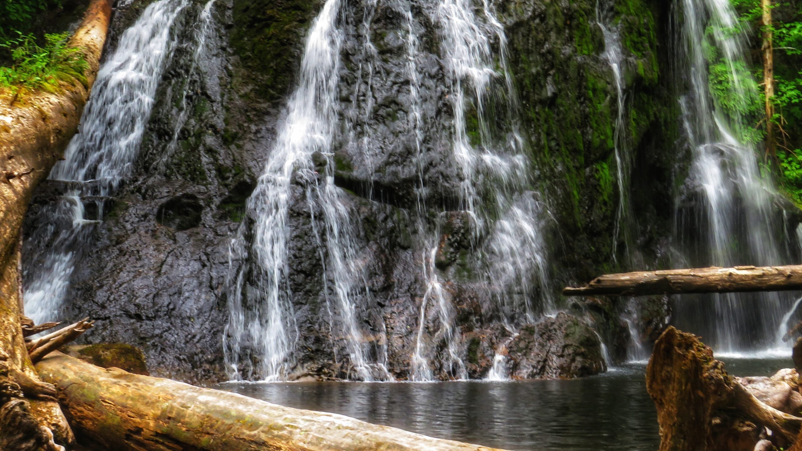
At the end of your hike, you’ll come upon a moderately steep section, which you must carefully descend in order to view the waterfall. The waterfall itself is quite nice; however, it is difficult to photograph on account of being obstructed by large logs. After enjoying the cascading falls and the sounds of nature, return the way you came.
4) To view the second waterfall, continue driving approximately 1.2 kilometres up the same narrow road. You will eventually see the trailhead markers – signified by candy cane patterned flagging tape – to your LEFT. A pullout, large enough for 2 vehicles, is just a few feet up the road. Unlike the first waterfall, the route to this second waterfall resembles a more traditional trail (albeit a little rough).
It, too, is extremely well marked with flagging tape. The total length of this trail is approximately 400 meters (one way), but that’s because, at the mid-point, it splits. If you go to the RIGHT, you’ll come upon the “top” of the falls, which is picturesque in its own right and features an attractive “kiddie pool” more than suitable for a swim.
If you go to the LEFT at the trail split, you’ll eventually make your way to a fairly large waterfall, cascading down a rounded rock face. Use caution, though: To get to these falls, you must descend an extremely steep area that, in one area, is almost completely vertical. There are several sturdy ropes to assist you here. Once you make it down, however, it is only a short walk to the impressive falls.
It is not uncommon for people to linger here for many a moment and cool off under the cascading water. Once you’re finished admiring the serene beauty laid out before you, simply head back the way you came.
Getting to these waterfalls may be tricky (both in navigating the narrow logging roads and hiking), but it is well worth the effort. In both instances, the waterfalls are a mere 10 to 15 minutes off the road. In our view, the second waterfall, in particular, is the major highlight because of its size and relative ease of access; in fact, we’d even suggest it rivals the Dover Falls in Sandspit!
Again, though, keep in mind that you will be driving on active logging roads; thus, proper caution should
be exercised. In addition, while a truck is not necessary to reach these sites, a standard vehicle is not ideal for these roads.
DIFFICULTY: Easy to Moderate
TOTAL DISTANCE: 400 and 800 meters (return)
TIME: 50 minutes (for both trails, out and back)
TYPE: Out-and-Back
ELEVATION GAIN: Minimal