


ANVIL TRAIL FEATURES:
Log Jam
Old growth forest
Interpretive hike
ABOUT
The Anvil Trail, which is located in the Tlall Conservancy, is one of the more popular trails on Haida Gwaii and is the only maintained route originally developed by the Tlell Watershed Society (TWS). It follows a 5-kilometre interpretive route and takes you through second-growth forests, old-growth, riparian floodplains, and even some minor boggy sections.
Much of the trail follows the meandering Tlell River before re-entering the dense forest and returning you to Highway 16, approximately 100 meters from where you started your journey.
The Anvil Trail takes you through several different environments and therefore becomes a destination in itself. When we did the hike, we opted to go against the grain and started our journey approximately 100 meters south of the standard trail entrance, which is located directly across from the Mariners Point parking lot. Of course, the entrance you choose is entirely up to you as the Anvil is ultimately a big loop trail.
The initial part of the Anvil Trail – at both entrances – is a dense and cluttered forest, very reminiscent of scenes from the Blair Witch Project (1999); however, after about 30 minutes, the trail does open up to more typical re-growth and much nicer scenery. At the 40-minute mark, if you’ve started your journey via the south entrance (as we did), you will come upon signage advising you to “NOT HIKE DOWNSTREAM FROM THIS POINT.”
That’s because there are 3 separate paths in this area: The orange route, which takes you to the log jam; the blue route, which is a “shortcut” and brings you to the other side of the orange loop, back towards Highway 16; and an unsigned/unmarked trail, which follows the Tlell River for roughly 2.5km before reconnecting with the orange route.
The early portion of the unmaintained trail appears decent enough; however, it very quickly becomes overgrown and virtually impossible to follow. The lesson here? Stay on the marked and maintained route!
Not long after this potentially disorienting area, the trail gets rather grown in and dense with salal bushes and other shrubs. At times, it almost felt like we needed a weed whacker! The trail also gets very miry at this point, but recent maintenance in the form of wooden stepping blocks has made navigating this section much easier.
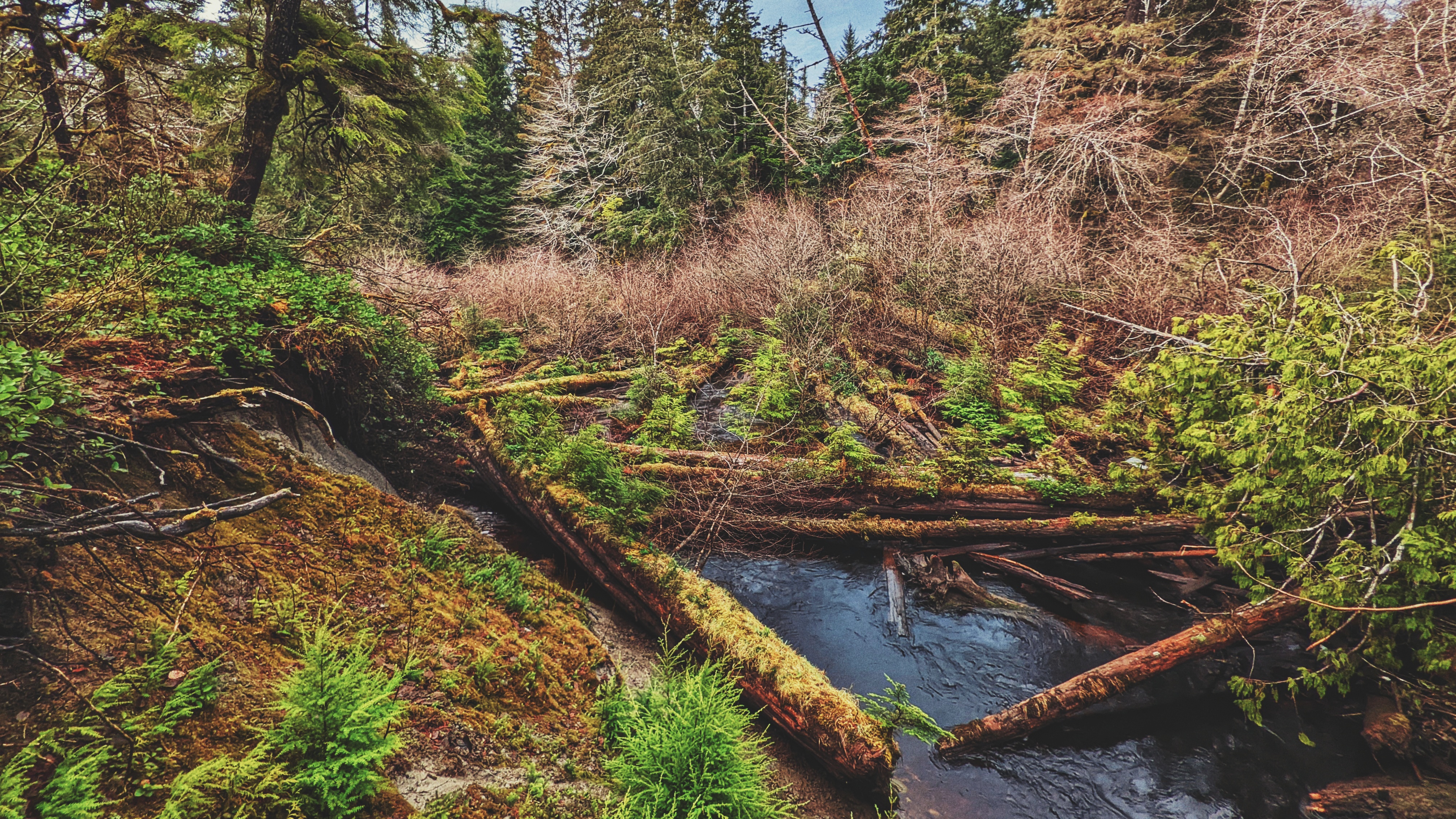
If you manage to power through, you’ll be rewarded with this trail’s major attraction – the log jam! It is quite a sight and extends for some 250 meters along the Tlell River.
According to the posted signage, the Great Fire of the 1840s contributed to the jam when many of the burnt and mangled trees fell into the river. There are some rough side trails here that allow you to get closer to the log jam, but we recommend viewing from up above.
From here on out, the trail loops back to Highway 16 and takes you through some lovely old-growth forest consisting of massive cedar and Sitka spruce trees.
While the hike is mostly uneventful at this point, you may still encounter a few areas where earlier storms have knocked over large trees and effectively blocked the trail, requiring some creative detours.
Once you reach the point known as the “Big Bend” (a few hours into your hike if entering from the south, or a mere 30 minutes if you began at the signed trailhead directly across from Mariners Point), you again come upon a confluence of trails.
The orange markers will take you to the log jam (or back to the Highway if you’re hiking FROM the log jam); the blue markers represent a “shortcut” to the opposite end of the Anvil Trail; and, you can also choose to walk EAST adjacent the Tlell River, along an unmarked and unmaintained trail.
This unmarked route is called the “Wiggins Road Trail” and, if you follow it for its full length – approximately 1.5km – you will eventually connect up to Wiggins Road. It’s a nice trail overall, but sections can be a little difficult to follow.
Overall, we’d say the Anvil Trail is worth the time and effort. The route is marked and the trail is nicely maintained for the most part. Furthermore, the interpretive signs throughout certainly enhance the experience and one’s appreciation of the Tlall Conservancy.
Oh, and if you’re wondering, “Why is it called Anvil Trail?” That’s because it follows a section of the Tlell River that, on the outline, resembles an anvil. How crazy is that?
DIFFICULTY: Easy
TOTAL DISTANCE: 5 kilometers
TIME: 3 hours
TYPE: Loop
ELEVATION GAIN: Minimal