

Pesuta Shipwrek – the trail is a mix of beach walks, river side, and forested parts The root system on the trail is a good massage to your soles (April 2021) 
The Geiki Creek Bridge (April 2021) The mouth of the Tllel River spilling to the ocean (May 2021) The shipwreck has been slowly being buried in the beach (Aug 2021)


Pesuta Shipwreck Trail Features
Shipwreck
East Beach access
Sand dunes
ABOUT
When travelling to Haida Gwaii, one will inevitably come across images of the Pesuta Shipwreck: It’s featured in tourist publications, there are beautiful pictures of it on BC Ferries, and countless bloggers have written about it online.
It’s become a symbol of the Islands similar to Balance Rock or the fallen Golden Spruce. Because of that, tourists seek it out and ensure it is part of an itinerary.
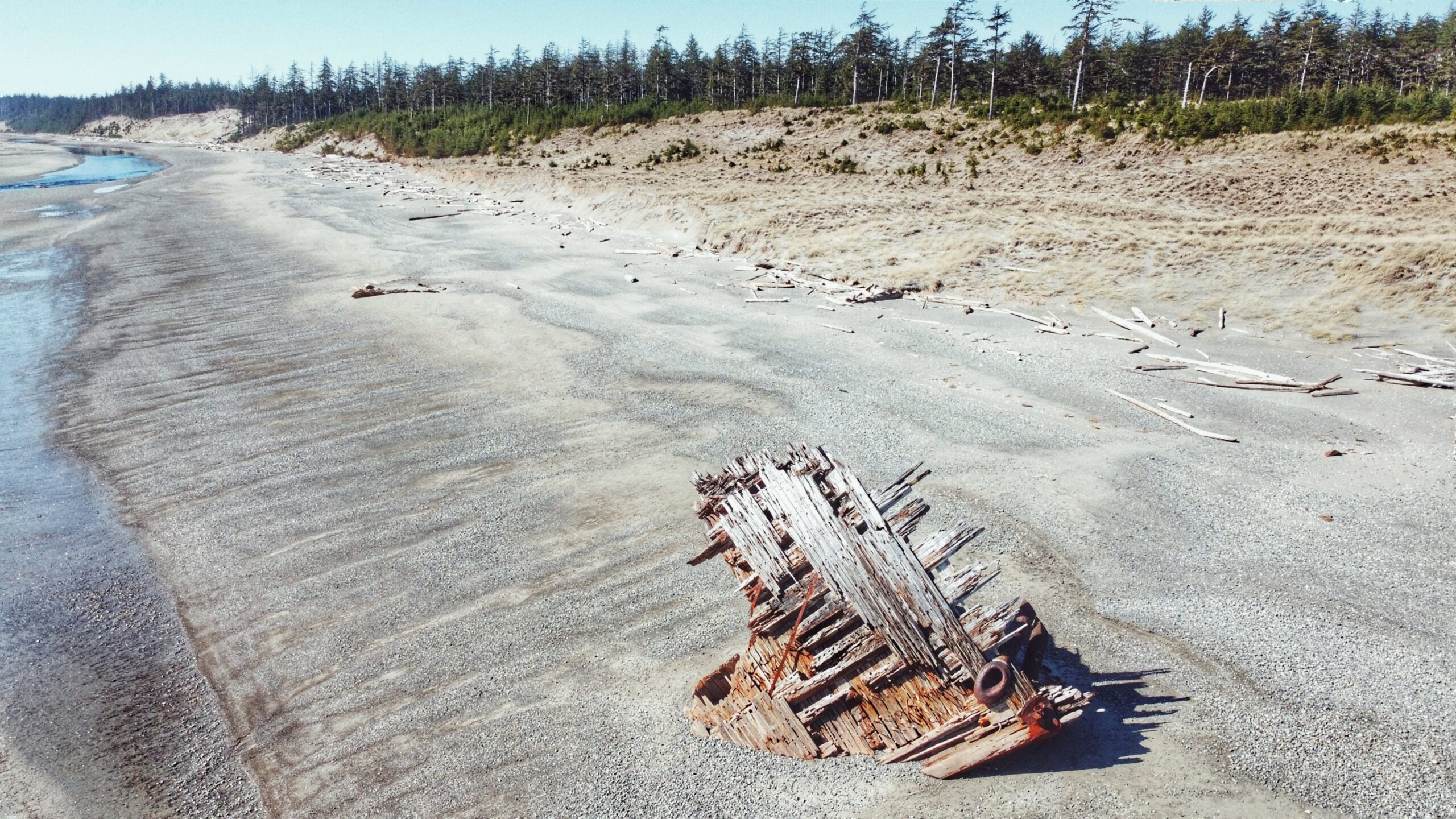
What is it about the Pesuta that draws so many? The story/context isn’t all that exciting. Basically, the Pezuta was built as a wood-hulled steam freighter during World War I and, after the war, she was sent to Seattle for “liquidation.”
In 1927, the Pezuta was converted into a 264-foot log barge capable of carrying an impressive 800,000 feet of logs. In December of 1928, the tugboat towing Pezuta struggled against a powerful storm in Hecate Strait; the big barge broke free and ran aground on East Beach, near the mouth of the Tlell River.
After nearly 100 years, just the bow remains to jut out from the sand; however, what’s left is extremely photogenic and eye-catching on a number of levels.
By the way, did you notice what we did there? Pezuta vs. Pesuta? At some point after the ship had run aground, the name got misspelled as “Pesuta” and that’s what ended up sticking. History can be funny at times.
The Pesuta Shipwreck Trail is probably the third-most-popular hiking trail on Haida Gwaii, only behind Tow Hill and the Blowhole. At 6 kilometres one-way (the posted signage at the trailhead says 5 km, but this doesn’t seem right), we’d suggest making this hike a nice day trip so as to truly enjoy the forest, river, beach and remnants of Pesuta.
When we hiked the route, it took about 2 hours and 35 minutes, one-way – and that was moving at a fairly leisurely pace. The trail is good for all skill levels because the route is mostly flat, with very little elevation gain.
To access the Pesuta Shipwreck Trail, simply visit the Tlell River Day Use area adjacent to the Tlell River Bridge. Here, you’ll see a few picnic tables and signage indicating the route. There’s also a pit toilet available.
We should also note that this site represents the start of the multi-day East Beach Trail hiking adventure. One day, when the Pesuta has completely gone back to nature, the “Pesuta Shipwreck Trail” will cease and only the East Beach Trail will remain.
The hike out to Pesuta is pretty straightforward. After passing the pit toilet, the trail splits in two – one path leads down to the river while the other heads up into the forest. Some have suggested taking the “tree portion” one-way and the “beach/river trail back,” but this is not advised because the riverbank near the Day Use area is mostly slippery silt for at least 1.5 kilometres. Trust us when we say it’s not fun to walk on!
Instead, follow the East Beach Trail signage (forest). The first 2 kilometres take you through a beautiful old-growth forest of Sitka Spruce, Cedar and lush, green moss.
During Spring, it is possible to observe Fairy Slippers in the moss. Indeed, this portion of the trail is well-marked and easy to navigate. For most of it, you walk along a ridge high above the Tlell River before briefly moving inland to cross Geikie creek.
We’d only advise using a bit of caution when walking along the ridge because the many tree roots do have the potential to trip you up! After clearing the forest, you spend the remaining 4 kilometres walking alongside the Tlell River until it empties into the Pacific Ocean.
From here, the Pesuta is visible in the distance, just a few hundred meters further up East Beach. On a clear day, this portion of the hike can be quite beautiful, especially as you walk past abandoned cabins and massive sand dunes. At the same time, it’s surprisingly hard on the feet!
Once you reach the Pesuta, it’s not uncommon to spend a fair amount of time here. We visited the wreck for a good hour, examining it and taking photos before making our way back to the trailhead (we lacked the stamina to walk the remaining 80+km up East Beach!).
The wreckage has a ghostly beauty to it: A visual memorial of humankind’s technology pitted against Mother Nature. The ship has sat here for nearly a century, getting beaten by waves and wind, and yet it’s still here – for now.
DIFFICULTY: Easy
TOTAL DISTANCE: 12 kilometers (return)
TIME: 5 hours
TYPE: Out-and-Back
ELEVATION GAIN: Minimal