Author: wanderbhyn

  • Five Mile Beach Trail – Short Hike to a Rocky Beach

    Five Mile Beach Trail – Short Hike to a Rocky Beach

    • Five Mile Trail
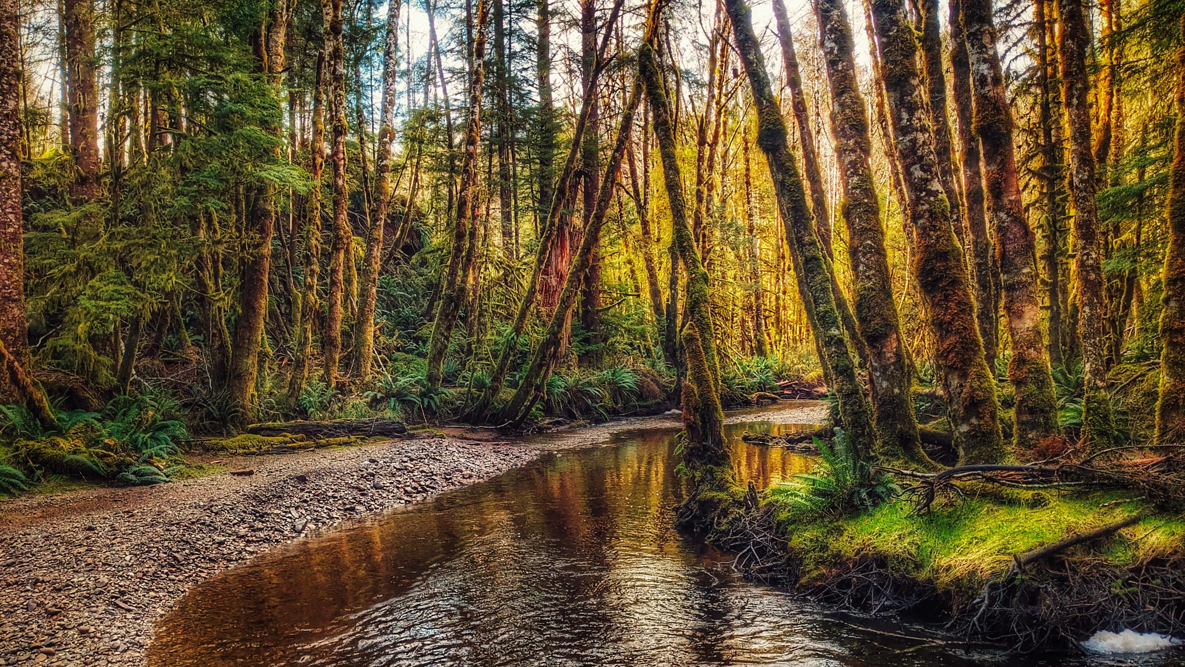
    • Five Mile Creek
    • Five Mile Trail
    • Five Mile Trail
    • Five Mile Trail

    Five Mile Beach Trail Features
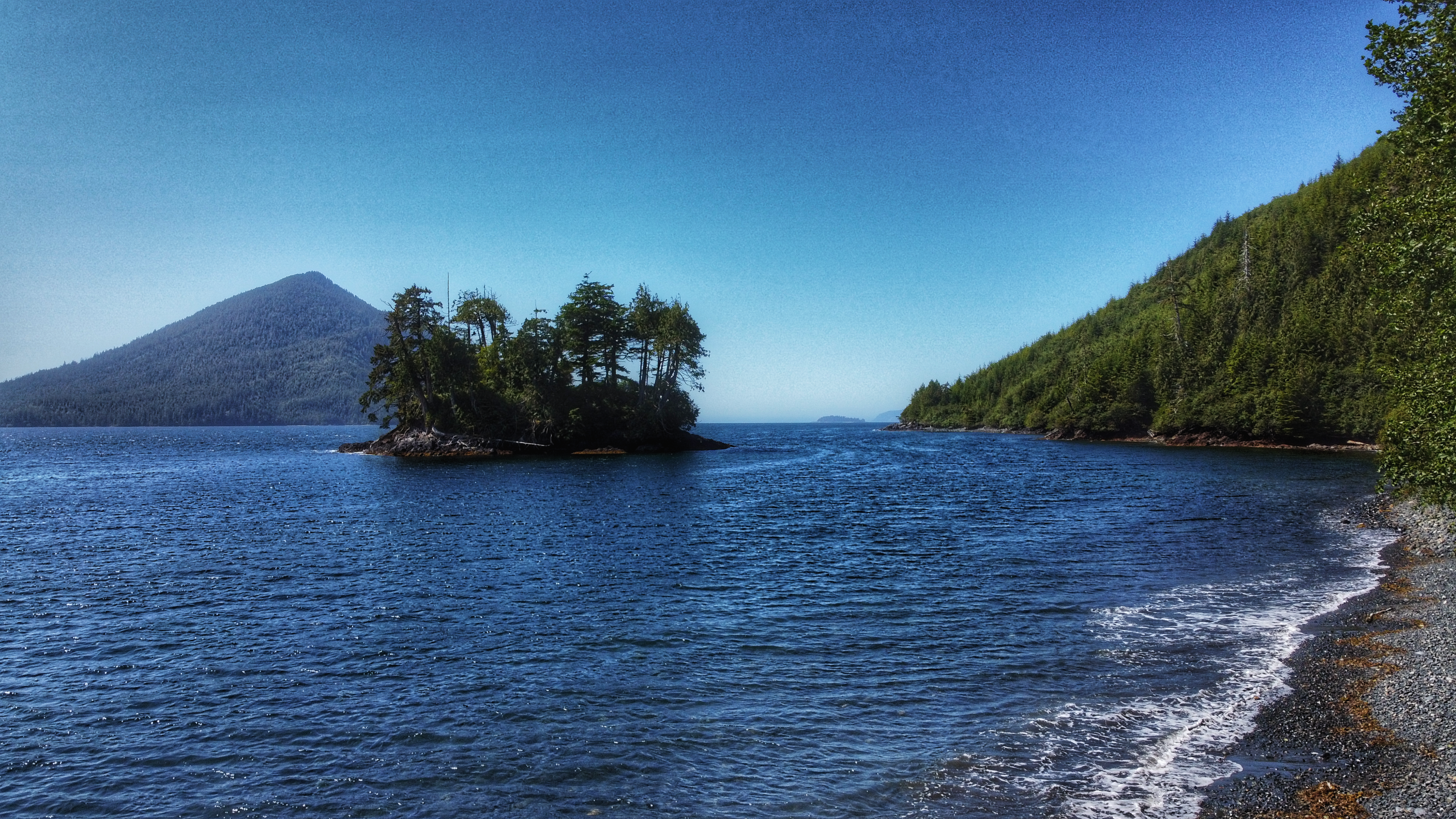
    – Five Mile Island view
    -Conehead view


    NOTE: Rennell Sound is subject to variable weather conditions, heavy rainfall, and landslide risk, particularly from September thru May. Be prepared for emergencies and road closures during weather events.


    ABOUT

    The Five Mile Beach Trail is located in Rennell Sound, just outside the Duu Guusd Conservancy. To reach this trail, and others in the area, one requires a good deal of patience and a high clearance vehicle because the old logging road out to Rennell is in poor shape and rife with large potholes. Once you make it, however, you will be rewarded with some of the most beautiful beaches anywhere in the world.

    If traveling from Daajing Giids, drive approximately 22 kilometers along the QC Mainline (use appropriate caution as these are active logging roads). You will come upon a blue sign with white text pointing you WEST towards the Duu Guusd Conservancy and Rennell Sound. You are now on the Rennell Sound Forest Service Road. From here, it is a 15 kilometer drive towards the Sound. Along the way, you will drive through Rennell Pass, including Rennell Hill with its steep 25% grade. While there is no longer active logging in this area, it is strongly recommended that you still drive with caution because the Rennell FSR is narrow and filled with significant potholes. For this reason, a high clearance vehicle is suggested.

    LOCATING THE TRAILHEAD

    Once at the bottom of Rennell Hill, you will come upon the Rennell Sound Recreation Site, which is rustic but features a boat launch, camping sites, and outhouses (no potable water). There are also beautiful views of the surrounding mountainscape. From here, drive approximately 3.7 kilometers north along the Rennell FSR. Once past the former dryland sort, you should spy the โ€œ5 Mile Beach BC Forest Recreation Trailโ€ sign to your LEFT. A small pullout with space for two or three vehicles is immediately behind the trailhead marker. Welcome to the Five Mile Beach Trail!

    HIKING THE TRAIL

    The Five Mile Beach Trail is short and straightforward. Clocking in at just 180 meters, it should take no more than a few minutes to reach the rocky beach. The trail, while not formally maintained, is clear. Step with caution as you near the beach, however, because there are some minor tree roots to watch out for. Once at the beach, take some time to admire the rocky shore, the surrounding mountains, and the eye-catching Five Mile Island. For those wishing to camp, there is space to set up a small tent just off the trail, adjacent the beach.

    DIFFICULTY: Easy
    TOTAL DISTANCE: 180 meters (one-way)
    TIME: Less than 5 minutes
    TYPE: Out-and-Back
    ELEVATION GAIN: None
  • Bonanza Beach – Arguably The Most Beautiful Beach on Haida Gwaii

    Bonanza Beach – Arguably The Most Beautiful Beach on Haida Gwaii

    • Bonanza Beach Haida Gwaii
    • Bonanza Beach Haida Gwaii
    • Bonanza Beach Haida Gwaii
    • Bonanza Beach Haida Gwaii
    • Bonanza Beach Haida Gwaii

    Bonanza Beach Features:
    Pristine sandy beaches
    Interesting tidal pools
    Surfer waves


    NOTE: Rennell Sound is subject to variable weather conditions, heavy rainfall, and landslide risk, particularly from September thru May. Be prepared for emergencies and road closures during weather events.


    ABOUT

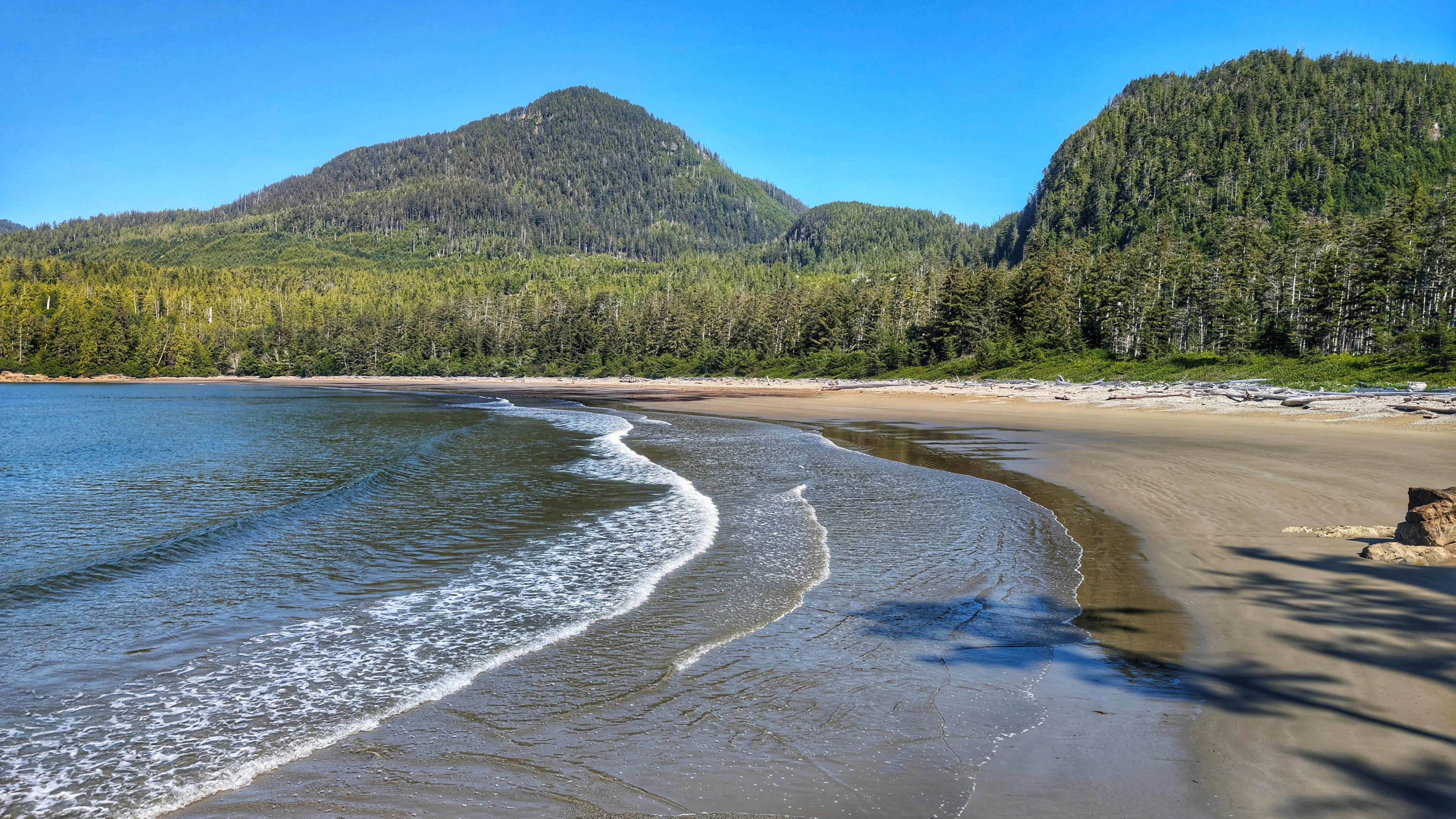
    Located within Rennell Sound and the Duu Guusd Conservancy, Bonanza Beach offers perhaps the finest sandy beach on all of Haida Gwaii. At the beachโ€™s south end you will find Bonanza Creek, which is home to spawning salmon in August and September. While remote and difficult to get to, Bonanza Beach is worth the effort and should be on everybodyโ€™s Haida Gwaii-themed bucket list.

    If traveling from Daajing Giids, drive approximately 22 kilometers along the QC Mainline (use appropriate caution as these are active logging roads). You will come upon a blue sign with white text pointing you WEST towards the Duu Guusd Conservancy and Rennell Sound.

    You are now on the Rennell Sound Forest Service Road. From here, it is a 15 kilometer drive towards the Sound. Along the way, you will drive through Rennell Pass, including Rennell Hill with its steep 25% grade (one of the steepest public roads in all of Canada). While there is no longer active logging in this area, it is strongly recommended that you still drive with caution because the Rennell FSR is narrow and filled with significant potholes. For this reason, a high clearance vehicle is suggested.

    LOCATING THE TRAILHEAD

    Once at the bottom of Rennell Hill, you will come upon the Rennell Sound Recreation Site. From here, drive north for approximately 14 kilometers along the Rennell FSR. You will pass the trailhead signs for Five Mile Beach, Riley Creek and Gregory Beach before coming upon the Bonanza River Bridge. While the bridge has been closed since August 2022 โ€œfor safety issues,โ€ locals have pushed the barricade aside to allow for vehicle access. The bridge remains structurally sound but, for those wishing to err on the side of caution, you can park your vehicle here and walk the 650 meters to the Bonanza Beach trailhead. Welcome to the Bonanza Beach Trail!

    HIKING THE TRAIL

    The trail to Bonanza Beach is brief @ only 400 meters one-way. As you hike towards the beach, you will be treated to second-growth forest, giant spruce burls, dense salal, and some beautiful old growth cedars as you approach the beach. It should take less than ten minutes for one to reach one of Haida Gwaiiโ€™s crown jewels: Bonanza Beach.

    Once you emerge from the dense salal, itโ€™s easy to see why the Daily Hive (2018), Love Exploring (2021) and MSN (2023), amongst others, have all listed Bonanza Beach as one of the top beaches in Canada. With its attractive crescent shape, Bonanza Beach is exposed to the powerful waves of the open Pacific Ocean. The relentless wave action has resulted in some of the finest sand on any beach in the world. It has also made this area attractive for surfers and beachcombers. Because Bonanza Beach is quite literally the โ€œlast stopโ€ on the way to Japan, it is not uncommon to find unique items along Bonanzaโ€™s shore, including the much sought after glass floats from Japanese fishing vessels.

    Lastly, weโ€™d be remiss if we failed to mention the tidal pools: On very low tides, Bonanza Beach is home to many attractive tidal pools, each teaming with life, including colourful sea anemones, beach crabs, mussels, life-giving seaweed and kelp. Indeed, the tidal pools offer a stunning microcosm of Duu Guusdโ€™s complex and rich marine environment.

    Bonanza Beach is โ€“ undoubtedly โ€“ a special place. For us, it highlights some of the best to be found within Duu Guusd: A short hiking trail with second and old growth forest; Haida cultural values; pristine
    beaches; epic views of Conehead and the open Pacific; and bountiful marine life, including salmon, King Fishers, bald eagles and even the odd seal. Having the opportunity to relax on the beach or swim in the ocean is just the icing on the cake.

    DIFFICULTY: Easy
    TOTAL DISTANCE: 400 meters (one-way)
    TIME: 7 minutes
    TYPE: Out-and-Back
    ELEVATION GAIN: None

  • Sachs Creek Trail: A Lovely Wilderness Hike

    Sachs Creek Trail: A Lovely Wilderness Hike

    • Sachs Creek Trail
    • Sachs Creek Trail
    • Sachs Creek Trail
    • Sachs Creek Trail

    Sachs Creek Trail Features
    Fishing spots
    Endemic tree frog sighting

    ABOUT

    Located roughly 1.6 kilometers east of the Moresby ferry waiting area, and just off Highway 16, you will find the informal Sachs Creek Trail. The trail is unmarked and isnโ€™t primarily used as a recreational hiking route; however, it is nevertheless listed in the Haida Gwaii Trails Strategy and Backroad Mapbooks (the latter resource is available at the Daajing Giids Visitor Centre). In the early 1980s, Sachs Creek was utilized as part of a UBC project that used tandem V-shaped gabion weirs for improving spawning habitat for pink and chum salmon. In more recent times, the creek has been used with some regularity by university students in environmental studies programs. Today Sachs Creek remains an important salmon-spawning creek. 

    LOCATING THE TRAILHEAD

    Because the trail is unmarked, getting to the trailhead can be a little tricky. If you are using the Backroad Mapbooks app, it will tell you to โ€œlook for a road branching south off the Highway 8km before Kwuna Point Road.โ€ Ignore this advice. The road it refers to is deactivated and so overgrown that it is unrecognizable as a road. Instead, if coming from the Kwuna ferry, drive approximately 600 meters along Highway 16. Shortly after crossing the Sachs Creek Bridge, you will see a narrow dirt road to your right. If you are driving a truck, it is possible to drive the 1.08 kilometers along this road to the unmarked Sachs Creek Trailhead; however, we recommend parking your vehicle on the wide curb and walking to the trailhead. There is no signage indicating you are on the Sachs Creek Trail. Instead, you will see an old logging road to your left and some alders and ferns to your right that lead down to Sachs Creek. The trail is characterized as a loop โ€“ albeit a rough and informal one โ€“ so it doesnโ€™t matter which route you take.

    HIKING THE TRAIL

    As of 2024, the area that encompasses the Sachs Creek Trail has become an active logging zone. As such, the tree tape you see along the old road, and in the forest along the creek, is unreliable; it does not denote the hiking route. In fact, the entire Sachs Creek Trail is unmarked. Thus, while 90% of the route follows old logging roads, the remaining 10% that brings you into the forest and along the creek can be challenging to navigate if you donโ€™t know where youโ€™re going. It is easy to get disoriented in the forest. For that reason, we donโ€™t recommend hiking this route unless you are using an app like BRMB, which contains an outline of the informal trail (note its rough heart shape!).

    Hiking along the old roads is a little one-note. If you choose to hike this informal trail, we recommend spending most of your time trekking along Sachs Creek and enjoying the rich flora and fauna of its banks and waters. Rich in nutrients and life, the creek remains important to the area. Depending upon the time of year, you might get lucky and spy schools of salmon swimming up the creek en route to their spawning grounds. Use caution, though, as taan (black bear) frequent the area.

    Note: With the area now an active logging zone, it may not be publicly accessible during working days of the week. As you walk the route, you will undoubtedly see clear evidence of the logging operations underway โ€“ many trees bear scars and itโ€™s a sad sight to see.

    DIFFICULTY: Moderate
    TOTAL DISTANCE: 3.5 kilometers
    TIME: 2 hours
    TYPE: Loop
    ELEVATION GAIN: 40 meters